
How 3D Scanning Transforms Emergency Restoration Documentation and Accelerates Insurance Claims

When disaster strikes — whether it’s a flood soaking through a family home, a fire tearing through a commercial property, or a storm leaving structural chaos in its wake — speed and accuracy in documentation can make or break the recovery process. Every delay increases stress for property owners and costs for restoration professionals and insurers alike.
Traditionally, documenting damage has been a slow, manual process — involving hundreds of photos, sketches, and handwritten notes that often leave gaps or inconsistencies. But as the restoration industry modernizes, 3D scanning is emerging as a game-changing tool. By capturing exact measurements and immersive digital replicas of damaged spaces, restoration teams can deliver precise documentation in hours instead of days.
The result is faster claims, fewer disputes, and a more transparent process for everyone involved — from contractors on-site to insurers assessing losses remotely. Let’s look at how traditional methods fall short and why 3D scanning is redefining restoration documentation.
The Challenge of Traditional Restoration Documentation
In the aftermath of a disaster, chaos is everywhere — standing water, charred beams, collapsed ceilings, and debris scattered across what used to be someone’s home or business. Restoration professionals are often the first to arrive after emergency responders, tasked with capturing the full extent of the damage before cleanup or rebuilding begins. In this critical first stage, documentation isn’t just a formality — it’s the foundation for insurance claims, project planning, and ultimately, customer trust.
Traditionally, this process has relied heavily on manual methods: taking dozens (sometimes hundreds) of photographs, jotting down handwritten notes, and sketching floor plans or damage zones by hand. While these techniques are familiar and accessible, they leave plenty of room for error. Photos can miss hidden damage or fail to capture scale. Notes can be lost, smudged, or misinterpreted. And hand-drawn diagrams often lack the precision insurers need to verify claims quickly.
The problem compounds when multiple stakeholders — restoration teams, adjusters, engineers, and property owners — are working from different sets of information. A missing measurement or unclear photo can spark rounds of back-and-forth communication, site revisits, and disputes over the extent of the loss. These inefficiencies slow down everything: claim approvals, project start times, and even customer satisfaction.
Worse still, traditional documentation methods depend heavily on the skill and consistency of whoever is on-site. A single missed photo or incomplete sketch can undermine the entire claim package. In high-pressure scenarios where teams are juggling multiple emergencies, maintaining accuracy and completeness becomes even more difficult.
As insurers push for faster processing times and property owners demand quicker resolutions, the limitations of these old approaches are becoming impossible to ignore. The restoration industry needs documentation methods that are faster, more accurate, and universally shareable — and that’s where 3D scanning is changing the game.
Introducing 3D Scanning in Restoration
Imagine being able to walk through a fire-damaged property without ever setting foot inside — viewing every room, every surface, and every inch of damage in perfect scale. That’s exactly what 3D scanning makes possible.
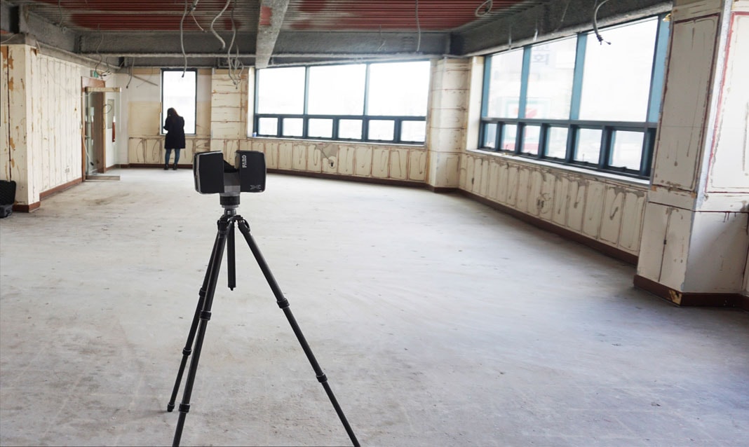
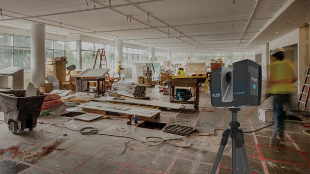
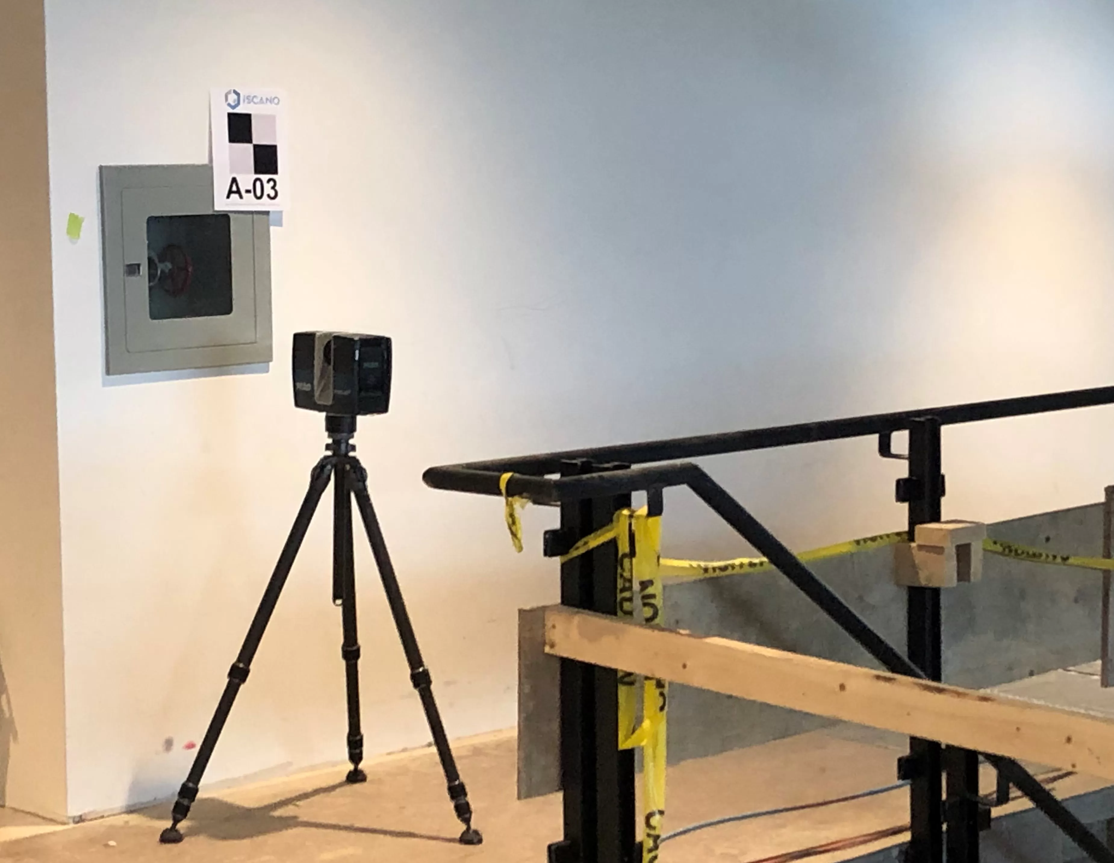
At its core, 3D scanning is the process of capturing a real-world environment in precise digital form. Using LiDAR sensors or photogrammetry-based cameras, restoration professionals can scan an entire property in minutes, generating a detailed, measurable 3D model. These scans capture millions of data points — mapping every wall, beam, and fixture down to millimeter accuracy — and stitch them into an interactive, virtual representation of the space.
In restoration contexts, this technology is especially powerful because it allows teams to document damage comprehensively before cleanup or demolition begins. Instead of relying on static photos or notes, insurers and contractors can access a full “digital twin” of the affected area, complete with exact dimensions, volumetric data, and geotagged details. This means there’s no ambiguity when it comes to verifying losses or estimating repair costs.
A growing number of tools make this possible. Handheld scanners, drones equipped with LiDAR, and even smartphones with depth sensors can now capture 3D data quickly and accurately. Once uploaded to cloud-based platforms, these scans can be viewed, measured, and annotated by all stakeholders — from restoration crews on-site to claims adjusters working remotely.
Consider a real-world example: A restoration company responding to a flood in a large office building. Instead of spending hours photographing each room and measuring water lines, the technician completes a full 3D scan in under an hour. The resulting model reveals not only visible damage but also subtle floor warping and ceiling sagging that would have been missed in 2D documentation. Within the same day, the insurer receives the 3D model, reviews it virtually, and approves the initial claim assessment.
The result is clear: 3D scanning doesn’t just document spaces — it captures the truth of the loss, offering a shared, data-rich foundation for faster decisions and fairer settlements.
How 3D Scanning Speeds Up Insurance Claims
Insurance claims are, by nature, detail-heavy and time-sensitive. Every damaged wall, soaked carpet, or cracked beam represents not only a repair cost but also potential contention between property owners, restoration contractors, and insurers. In traditional claims processes, the biggest bottleneck often isn’t repair work — it’s the documentation and verification stage. That’s where 3D scanning has proven to be a revolutionary tool, accelerating every step from assessment to settlement.
The key advantage of 3D scanning is its ability to capture complete and verifiable site data in a single visit. Restoration professionals can scan the entire property immediately after a disaster, preserving a high-fidelity record of the loss. This rapid site capture eliminates the need for multiple return visits, which are often required when insurers request additional photos or measurements.
Once the scan is processed, the data is uploaded to a secure cloud platform. From there, insurance adjusters can view the property remotely, navigate through the 3D model, and take their own measurements without waiting for additional information. This creates an entirely new level of transparency — the insurer sees exactly what the restoration team saw, ensuring everyone is working from the same source of truth.
Here’s a simplified breakdown of how 3D scanning accelerates the insurance claim lifecycle:
- Rapid site capture – Within hours of the loss, a full 3D model is created, capturing every angle and measurement.
- Instant sharing and collaboration – Digital files are uploaded to a cloud platform, accessible by adjusters, clients, and project managers.
- Faster verification – Insurers can independently measure rooms, verify damage, and validate claims using the 3D environment.
- Reduced disputes and revisits – Because the data is both accurate and permanent, disagreements about scope or extent of damage are minimized.
The time savings can be dramatic. A process that once took weeks — involving phone calls, multiple inspections, and back-and-forth revisions — can now be completed in days. In some reported cases, 3D scanning has reduced claim review time by up to 70%, allowing contractors to start restoration sooner and insurers to process payouts faster.
Equally important, 3D data provides a verifiable audit trail. Because each scan is timestamped and geolocated, it serves as defensible documentation that can be revisited later if any questions arise about the property’s condition at the time of loss. This protects both restoration companies and insurers from liability and dispute escalation.
Ultimately, 3D scanning transforms claims from subjective assessments into objective digital evidence. By merging accuracy, transparency, and accessibility, it redefines what “fast and fair” means in the world of insurance restoration.
Collaboration and Transparency Through 3D Data
In the restoration and insurance world, miscommunication can be costly. A missed measurement, unclear photo, or conflicting interpretation of the damage can cause weeks of delay and erode trust between contractors, insurers, and property owners. One of the most transformative benefits of 3D scanning is that it replaces fragmented documentation with a shared, data-rich model everyone can access — creating unprecedented levels of collaboration and transparency.
When a 3D scan is uploaded to a secure cloud platform, it becomes a living, interactive digital record of the property. Multiple users — restoration teams, insurance adjusters, estimators, and even homeowners — can log in and explore the environment as if they were standing in it. They can pan through rooms, take real-time measurements, or zoom into specific details to examine the extent of water damage or smoke residue. This shared visibility drastically reduces miscommunication, because everyone is literally seeing the same thing.
For insurers, this transparency means faster decision-making. Adjusters no longer have to rely on incomplete photos or third-party interpretations. They can independently verify data and measurements, often approving claims remotely without additional inspections. For contractors, it ensures their documentation is fully defensible — no longer subject to the subjectivity of field notes or differing opinions.
This level of shared clarity also builds confidence for property owners. Instead of feeling left out of a complex, jargon-filled process, they can visualize the full scope of their damage through the same 3D model used by professionals. This not only increases trust but also helps manage expectations for the restoration timeline and outcome.
Collaboration doesn’t stop at viewing. Many 3D scanning platforms now include built-in commenting, tagging, and integration with estimating software. Adjusters can mark problem areas directly in the model, restoration teams can respond with proposed repairs, and all changes are tracked in real time. Every stakeholder sees the same data updates, which keeps communication tight and projects moving smoothly.
By replacing static, siloed information with a shared 3D environment, the entire claims ecosystem becomes more efficient and transparent. No more second-guessing. No more duplicate site visits. Just clear, measurable, collaborative data driving faster, fairer outcomes.
Integration and Best Practices for Using 3D Scanning in Restoration
While the benefits of 3D scanning are clear, success depends on how well restoration teams integrate the technology into their day-to-day operations. To get the most from 3D documentation, it’s not just about buying the right hardware — it’s about creating the right workflow, training, and data strategy.
1. Choose the Right Equipment and Software
The first step is selecting technology suited to your project scale and budget.
- Handheld LiDAR scanners are ideal for small to medium-sized residential losses where mobility and speed matter.
- Tripod-mounted or terrestrial scanners offer the highest accuracy for large commercial projects.
- Mobile photogrammetry apps can supplement traditional methods for quick captures when full 3D scanning isn’t feasible.
Equally important is the software ecosystem — platforms that process, store, and visualize scans. Look for cloud-based tools that allow easy sharing with insurers and the ability to export data to estimating or CAD software.
2. Train Staff for Accurate and Consistent Scanning
Even with advanced tools, human technique matters. Restoration technicians should be trained not only in operating scanners but also in understanding what to capture and why. Scanning from multiple angles, ensuring full coverage of critical areas (like ceilings and foundations), and following standardized procedures will ensure consistent, usable results. The goal is to make every scan defensible, detailed, and repeatable.
3. Streamline Data Management and Security
3D scans are massive datasets — sometimes several gigabytes per project. Efficient file naming, cloud organization, and access control are key to keeping things running smoothly. Restoration firms should establish policies for:
- Data storage and retention — keeping scans available for future audits or re-inspections.
- Privacy and compliance — especially when handling sensitive information from insured properties.
- Access permissions — ensuring only authorized personnel and insurers can view or modify data.
Secure data management isn’t just about convenience — it builds trust with clients and insurers by demonstrating professionalism and accountability.
4. Integrate 3D Data into Existing Claim and Estimating Workflows
The true power of 3D scanning emerges when it connects seamlessly to your existing claim systems. Many platforms now integrate directly with insurance estimating tools like Xactimate or CoreLogic. This means damage measurements from 3D scans can automatically populate estimate line items — eliminating redundant data entry and reducing human error.
When everyone — from field techs to estimators to adjusters — works from the same dataset, claim accuracy and speed both improve dramatically.
5. Collaborate Early and Often with Insurers
Finally, bring insurers into the process from the start. Some carriers are already requiring or recommending 3D documentation, while others are just beginning to explore it. Sharing your workflow, scan examples, and turnaround times helps build confidence and positions your restoration company as a technology-forward partner.
When integrated thoughtfully, 3D scanning doesn’t just modernize restoration — it becomes the standard of trust between contractors, insurers, and clients.
The Future of 3D Scanning and AI in Restoration
As restoration technology continues to evolve, 3D scanning is only the beginning. The future lies in how these high-fidelity digital environments integrate with artificial intelligence (AI), automation, and predictive analytics to transform the entire insurance and restoration ecosystem.
The most exciting development is AI-assisted damage detection. Advanced algorithms can now analyze 3D scans to automatically identify and categorize damage — from smoke discoloration on walls to warped flooring or water intrusion patterns. This automation helps adjusters and estimators save hours of manual inspection time while improving the consistency and objectivity of assessments.
Beyond detection, AI is also being applied to automated estimating. By combining scan data with standardized cost databases, future systems will be able to generate preliminary repair estimates instantly after a scan is uploaded. This level of automation will drastically reduce administrative workload, allowing restoration professionals to focus on what matters most: getting properties and lives back to normal faster.
We’re also seeing rapid advances in predictive modeling. With enough data from past losses, 3D and AI systems can forecast likely repair costs and timelines based on the type and extent of damage. Over time, this predictive capability could help insurers better understand risk profiles — even before a disaster occurs.
On the hardware side, mobile and drone-based scanning are making 3D capture more accessible and faster than ever. Drones equipped with LiDAR or photogrammetry can scan large commercial roofs or inaccessible disaster zones safely and efficiently. Meanwhile, smartphones with depth-sensing capabilities allow smaller contractors to perform quick scans without investing in expensive gear.
Ultimately, the combination of 3D scanning and AI is steering the restoration industry toward a fully data-driven future — one where every loss is captured, analyzed, and settled with unparalleled accuracy and speed.
The days of manual measuring tapes and photo folders are fading. In their place, digital models and intelligent analysis tools are creating a restoration process that’s faster, fairer, and more transparent than ever before.
Conclusion
In the fast-paced world of emergency restoration, documentation is everything. The sooner and more accurately a property’s damage is recorded, the faster the path to recovery — for both contractors and property owners.
3D scanning has revolutionized this process. It replaces guesswork with precision, bringing speed, accuracy, and clarity to every stage of the insurance claim. By capturing complete digital replicas of damaged spaces, restoration professionals can provide indisputable documentation that insurers trust. Adjusters gain remote access to verifiable models, contractors reduce delays, and homeowners experience faster resolutions — a win for everyone involved.
The key takeaways are clear:
- 3D scanning dramatically accelerates restoration documentation and claim processing.
- Shared 3D data fosters collaboration and transparency among all stakeholders.
- Integrating modern scanning workflows sets the foundation for a smarter, more efficient restoration process.
As technology continues to evolve, the next frontier is data capture services — systems that combine 3D scanning, imagery, and metadata into one seamless, managed package. These services handle everything from field data collection to cloud organization and delivery, ensuring your documentation is not only accurate but immediately actionable. For restoration firms and insurers alike, partnering with a professional data capture provider means faster claims, better quality assurance, and less time lost to manual documentation.
The future of restoration belongs to those who embrace digital precision. If your team is ready to streamline its claims workflow and gain a competitive edge, exploring a comprehensive data capture service is the natural next step.
Prefer to Speak Directly?
Experience precision in every project.
