
Top Software Tools for As-Built Documentation
Key Software Tools for Creating and Managing As-Built Documentation
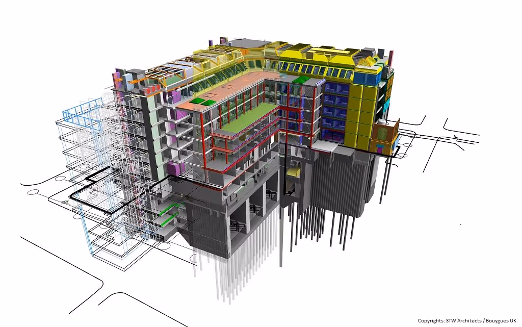
Accurate as-built documentation is fundamental to the successful completion of construction projects and the efficient long-term management of facilities. Creating these crucial records—which reflect the actual, final state of a project—relies on a range of sophisticated software tools. These tools assist in every stage, from initial data capture and processing to modeling, drafting, and ultimately, managing and sharing the as-built information. This page highlights the key categories of software and prominent examples used in modern as-built documentation workflows.
Want a precise record of how your building actually exists today? Our As-Built Documentation Service delivers detailed CAD and BIM-ready files to support renovations, compliance, and accurate facility management.
Software Categories in the As-Built Workflow
The creation and management of as-built documentation typically involve several stages, each supported by specialized software:
- Data Capture: Acquiring raw data from the field.
- Data Processing: Refining and preparing the raw data.
- Modeling & Drafting: Creating the actual as-built drawings or models.
- Management & Collaboration: Storing, sharing, and managing the final documentation.
1. 3D Scanning and Reality Capture Software
This software category is used to operate 3D scanners (like LiDAR and Matterport systems) and perform initial processing of the captured data, primarily point clouds.
- Purpose: Controlling scanner operations during data acquisition, performing initial data alignment (registration) of multiple scans, and basic point cloud viewing and cleaning.
- Key Features: Direct scanner interface, automated and manual scan registration tools, point cloud visualization, basic measurement and annotation tools, data export in various formats.
- Prominent Examples:
- Leica Cyclone: A comprehensive software family for use with Leica Geosystems scanners (which Data Capture Service utilizes). Modules like Cyclone REGISTER 360 are widely used for registering and georeferencing scan data.
- Faro SCENE: Designed for processing and managing scan data from Faro laser scanners, offering tools for registration, measurement, and visualization.
- Autodesk ReCap Pro: A popular tool for importing, registering, and processing point cloud data from various scanners, preparing it for use in other Autodesk design software.
- Matterport Capture App & Cloud Platform: An integrated system for controlling Matterport cameras, processing scans into 3D tours and models, and hosting the data (Data Capture Service uses this for immersive tours and visual documentation).
- Trimble RealWorks: Software for registering, analyzing, modeling, and creating deliverables from point cloud data from virtually any source.
- How it supports as-builts: This software provides the foundational, high-accuracy point cloud data that represents the true existing conditions of a site or structure, forming the basis for all subsequent as-built creation.
Capture current site conditions quickly and accurately with industry-leading LiDAR technology. Our 3D Scanning Services provide high-fidelity point clouds for design, verification, and documentation.
2. Point Cloud Processing and Analysis Software
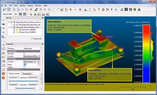
While some initial processing occurs in the capture software, more advanced processing, analysis, and manipulation of point clouds often require dedicated tools.
- Purpose: Advanced cleaning (noise reduction, outlier removal), editing, segmenting point clouds, creating meshes, performing detailed analysis, and extracting features.
- Key Features: Advanced filtering algorithms, point cloud classification (e.g., ground, vegetation, buildings), mesh creation and editing, deviation analysis (comparing point clouds to models), feature extraction tools.
- Prominent Examples:
- Autodesk ReCap Pro: Offers robust processing and analysis features.
- Leica Cyclone 3DR: Provides advanced inspection and meshing capabilities from point cloud data.
- Trimble RealWorks: Includes tools for deep processing and analysis.
- CloudCompare: A powerful open-source software for 3D point cloud and mesh processing, widely used for analysis and comparison.
- Topcon Magnet Collage: Software for processing and combining data from various sensors, including laser scanners and photogrammetry.
- How it supports as-builts: Refines raw scan data into a clean, optimized, and more interpretable format, making it easier to create accurate models or drawings, and to perform detailed checks against design intent.
3. CAD (Computer-Aided Design) Software
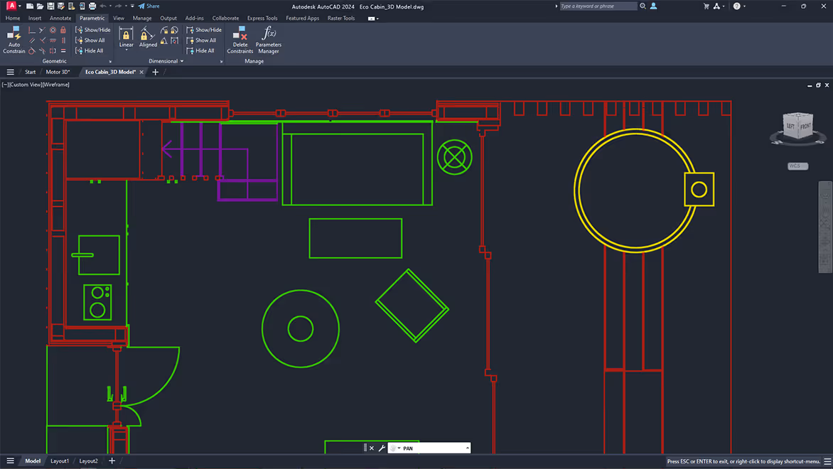
CAD software remains a staple for creating traditional 2D as-built drawings and, in some cases, 3D geometric as-built models.
- Purpose: Drafting 2D as-built plans, sections, and elevations, or creating 3D models, often by referencing point cloud data or using information from traditional surveys and red-line markups.
- Key Features: Comprehensive 2D drafting tools (lines, arcs, dimensions), 3D solid and surface modeling capabilities, ability to import/attach point clouds as a visual and geometric reference.
- Prominent Examples:
- Autodesk AutoCAD: The industry-standard CAD software, widely used for producing 2D as-built drawings. Data Capture Service often provides deliverables in AutoCAD format.
- Bentley MicroStation: Another powerful CAD platform used in infrastructure and large-scale projects.
- BricsCAD: A CAD platform offering 2D drafting and 3D modeling with good point cloud support.
- Specialized CAD plugins for point clouds (e.g., Undet, PointSense for AutoCAD): These plugins enhance CAD software with tools specifically designed for working with point clouds, such as slicing, feature extraction, and semi-automated drawing.
- How it supports as-builts: Enables the creation of precise 2D documentation that reflects the as-constructed state, a common deliverable requirement. The "Scan to CAD" workflow relies heavily on these tools.
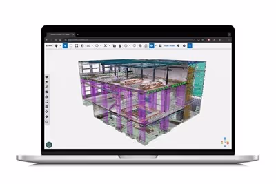
4. BIM (Building Information Modeling) Authoring Software
For creating intelligent, data-rich 3D as-built models, BIM authoring software is essential. The "Scan to BIM" process leverages these tools.
- Purpose: Developing intelligent 3D as-built BIM models where elements (walls, pipes, equipment) are represented as smart objects with embedded data, accurately modeled from point cloud references.
- Key Features: Object-based modeling (walls, doors, structural elements, MEP systems), parametric capabilities, ability to import/link point clouds, tools and plugins for modeling from point cloud data, data management and scheduling.
- Prominent Examples:
- Autodesk Revit: A leading BIM platform extensively used for architectural design, MEP, and structural engineering, and a primary tool for Scan to BIM workflows. Data Capture Service delivers As-Built BIM models in Revit.
- Graphisoft ArchiCAD: A popular BIM software primarily among architects, also with capabilities for creating as-built models.
- Bentley OpenBuildings Designer (formerly AECOsim): A multidisciplinary BIM application for designing, analyzing, documenting, and visualizing buildings.
- Tekla Structures: Specialized BIM software for structural engineering, particularly steel and concrete detailing.
- How it supports as-builts: Creates a comprehensive and intelligent digital twin of the as-constructed facility, invaluable for lifecycle management, future renovations, and advanced analysis.
Make better decisions throughout your project lifecycle with data-rich existing-condition reports. Our Building Surveys Services deliver comprehensive and accurate surveys tailored to your needs.
5. BIM Collaboration and Model Review Software
These tools are used to combine (federate) models from different disciplines, navigate them, review them for issues, and perform analyses like clash detection.
- Purpose: Aggregating multidisciplinary BIM models (including as-built models), facilitating model review, issue tracking, and performing clash detection between as-built conditions and new design proposals or between different installed systems.
- Key Features: Support for various file formats, model navigation and visualization, markup and commenting tools, robust clash detection engines, reporting capabilities.
- Prominent Examples:
- Autodesk Navisworks: Widely used for model aggregation, clash detection, 4D simulation, and project review.
- Solibri Model Checker: Focuses on BIM quality assurance, code compliance checking, and advanced clash detection.
- Trimble Connect: A cloud-based collaboration platform allowing teams to view, share, and access project information, including 3D models.
- BIMcollab Cloud and ZOOM: A platform for issue management and model validation in BIM projects.
- How it supports as-builts: Enables verification of as-built models against design intent or other trade models, helps identify and manage discrepancies, and facilitates collaborative review of the as-built state.
Reduce coordination risks and improve project outcomes by converting point clouds into detailed BIM models. Use our Scan to BIM Services to support clash detection, design validation, and digital twin development.
6. Field Software and Mobile Applications
Mobile tools are increasingly used on-site for data collection, progress tracking, and accessing project information, contributing to the as-built process.
- Purpose: Capturing supplementary as-built data in the field (e.g., photos, videos, notes, digital red-lines), accessing drawings and models on mobile devices for verification.
- Key Features: Mobile viewing of 2D plans and 3D models, photo and video documentation linked to locations, digital markup tools, form filling for inspections and reports, task management.
- Prominent Examples:
- Autodesk Construction Cloud (ACC - formerly BIM 360): A suite of tools for field management, document control, and project collaboration.
- Procore: A comprehensive construction management platform with strong field capabilities.
- Fieldwire by Hilti: A jobsite management platform for construction teams, offering plan viewing, task management, and as-built markup features.
- Bluebeam Revu: Primarily a PDF markup tool but widely used in the field for red-lining and as-built annotations.
- Scanner-specific mobile apps (e.g., Leica Cyclone FIELD 360, Matterport Capture): Allow for remote control of scanners, on-site scan registration previews, and data tagging in the field.
- How it supports as-builts: Facilitates the real-time or near real-time collection of as-built information directly from the construction site, improving accuracy and reducing delays in data transfer.
7. Common Data Environments (CDEs) and Document Management Systems
A centralized platform for managing all project information, including the final as-built documentation, is crucial.
- Purpose: Securely storing, organizing, managing versions, and controlling access to all project documents and models, ensuring that all stakeholders are working with the correct and latest as-built information.
- Key Features: Version control, access permissions, collaborative workflows, audit trails, search functionality, integration with other project management tools.
- Prominent Examples:
- Autodesk Construction Cloud (ACC): Provides a CDE for BIM and construction data.
- Bentley ProjectWise: An enterprise-level system for managing engineering project content and workflows.
- Trimble Connect: Offers CDE capabilities for AEC projects.
- Procore: Includes robust document management features.
- Oracle Aconex: A widely used CDE for large-scale construction projects.
- How it supports as-builts: Ensures that the final, approved as-built documentation is the single source of truth, securely stored, easily accessible to authorized personnel throughout the building's lifecycle, and properly versioned.
Choosing the Right Software Stack
No single software tool can perform every task in the as-built documentation lifecycle. AEC firms and service providers typically use a "stack" or combination of these tools, selected based on:
- Specific project requirements and deliverables (2D CAD, 3D BIM, virtual tours).
- The types of data capture methods being used (3D scanning, traditional survey, manual markups).
- Company size and existing software ecosystem.
- Budget and licensing costs.
- The need for interoperability between different software platforms.
The Role of Service Providers Like Data Capture Service
Specialized service providers like Data Capture Service invest in and maintain expertise with a suite of professional-grade reality capture and modeling software. Clients benefit from this expertise and access to advanced tools without needing to make the significant investment in hardware, software, and ongoing training themselves. We focus on efficiently capturing precise existing condition data and delivering it in industry-standard formats, such as AutoCAD (DWG) and Revit (RVT), that seamlessly integrate into our clients' established design and documentation workflows.
The effective creation and management of as-built documentation in the modern AEC industry are heavily reliant on a diverse ecosystem of software tools. From capturing reality with 3D scanners to modeling intelligent BIM objects and managing information in a common data environment, these software solutions empower professionals to produce more accurate, comprehensive, and valuable as-built records. The trend is clearly towards increasingly integrated digital workflows, often initiated by precise reality capture as the foundational step.
Transform the way you document, model, and showcase your built environments with our comprehensive range of professional services:
- As-Built Documentation Services
- Scan to BIM Services
- 3D Scanning Services
- Floor Plans Creation Services
- Building Surveys Services
- Virtual Tours Creation Services
Ready to explore in more?
Start here:
How Architects Use As-Built Data in Renovation
Prefer to Speak Directly?
Experience precision in every project.
