
How Architects Use As-Built Data in Renovation
Faster, More Accurate As-Builts: The Power of 3D Scanning
Accurate as-built documentation is a cornerstone of successful construction projects and efficient facility management. It provides a definitive record of a project as it was actually constructed. However, traditional methods for creating these crucial documents can be slow, labor-intensive, and susceptible to errors and omissions. Modern 3D scanning technology offers a transformative solution, revolutionizing the as-built process by delivering unparalleled speed, accuracy, and completeness.
The Bottlenecks of Traditional As-Built Creation
Understanding the limitations of older methods highlights why 3D scanning is such a game-changer:
- Manual Field Measurements: This involves technicians physically measuring distances, heights, and locations using tools like tape measures, laser distos, or total stations for discrete points. This is inherently time-consuming, especially for large or complex spaces. It's also prone to human error in reading, recording, and transcribing measurements. Capturing comprehensive data for intricate MEP systems or irregular architectural features is exceptionally challenging.
- Red-Line Markups: This common practice relies on site personnel diligently marking up original design drawings by hand to indicate deviations. The quality of these red-lines can vary greatly; they may be inconsistent, illegible, incomplete, or misinterpreted later. Transferring these manual annotations to clean digital files can be a slow process and introduce further errors.
- Data Silos and Inconsistencies: Information for as-builts often comes from various trades and subcontractors. Compiling this disparate information into a cohesive and accurate final document can be difficult, leading to inconsistencies.
- Verification Challenges: Thoroughly verifying the accuracy and completeness of manually collected as-built data across an entire project is a daunting, if not impossible, task. This often leads to a lack of confidence in the final documentation.
Make complex renovations easier with accurate models of your existing facility. Our As-Built Documentation Service delivers precise CAD and BIM outputs that eliminate guesswork and save time during construction.
How 3D Scanning Transforms As-Built Documentation
3D scanning technologies, such as LiDAR (Light Detection and Ranging) and advanced photogrammetry, address the shortcomings of traditional methods head-on:
- Rapid Data Acquisition:
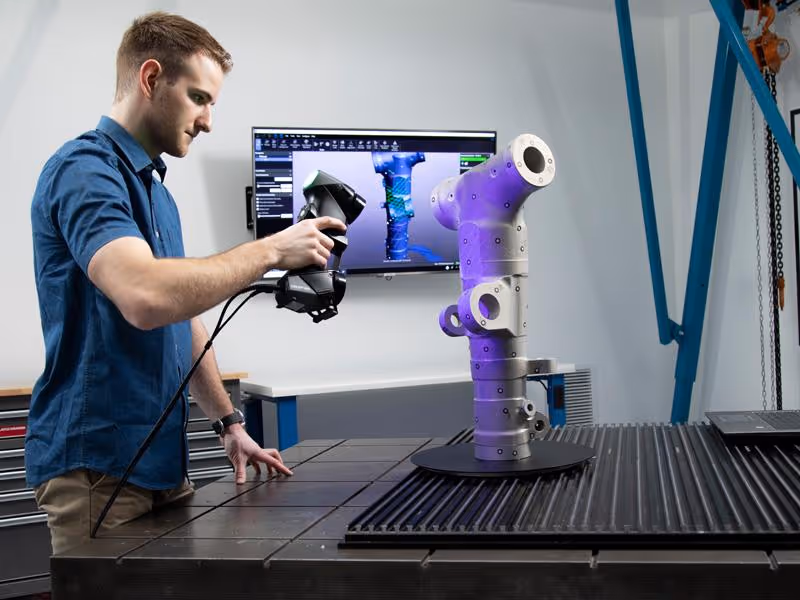
- Modern 3D laser scanners can capture millions of precise data points per second, creating a dense and accurate 3D "point cloud" of a site or structure in a matter of hours, rather than days or weeks that manual methods might take for comparable detail.
- This significantly reduces the time personnel need to spend on-site for field verification and data collection.
- Unparalleled Accuracy and Detail:
- 3D scanners, particularly survey-grade LiDAR systems, can achieve millimeter-level accuracy. This minimizes the human error inherent in manual measurements.
- The resulting point cloud provides a far more complete and detailed dataset, capturing the precise geometry and location of all visible surfaces and objects, not just a selection of discrete points.
- Comprehensive Coverage:
- 3D scanning excels at capturing complex geometries, congested MEP (Mechanical, Electrical, Plumbing) spaces, ornate architectural features, and irregular surfaces that are exceptionally difficult or time-consuming to document manually.
- This comprehensive capture reduces the risk of missing critical information that could impact future renovation, maintenance, or facility management.
- Rich and Versatile Data Deliverables:The processed scan data can be transformed into various valuable as-built deliverables:
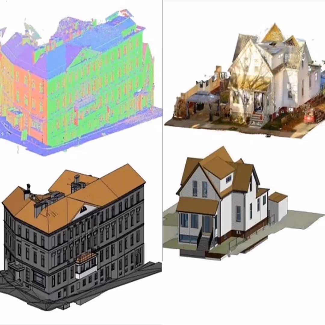
- Point Clouds: The direct output – a rich 3D dataset that can be used for visualization, virtual walk-throughs, and taking precise measurements.
- 2D As-Built Drawings: Highly accurate and detailed 2D plans, sections, and elevations can be extracted directly from the point cloud data, ensuring they reflect true conditions.
- 3D As-Built Models (Scan to BIM/CAD): The point cloud serves as a precise template for creating intelligent As-Built BIM models (e.g., in Revit) or accurate 3D CAD models. Data Capture Service specializes in converting scan data into these robust models.
- Improved Safety:
- Scanning can often be performed from a safe distance, reducing or eliminating the need for personnel to physically access hazardous, unstable, or difficult-to-reach areas (e.g., high ceilings, confined spaces, structurally compromised zones) for manual measurements.
- Enhanced Collaboration and Communication:
- The digital nature of 3D scan data (point clouds, derived models, and virtual tours) allows for easy sharing among all project stakeholders. This provides a clear, unambiguous, and universally accessible visual record of the as-built conditions, improving understanding and reducing misinterpretations.
The "Scan to As-Built" Workflow in Practice
Leveraging 3D scanning for as-builts typically follows these steps:
- Planning and Site Scanning: Defining the project scope and then rapidly capturing the existing conditions using advanced 3D laser scanners.
- Data Processing and Registration: The collected scan data (point clouds) is cleaned, filtered, and precisely aligned (registered) to create a unified and accurate 3D representation of the site.
- Modeling and/or Drafting from Point Cloud:
- For Scan to CAD As-Builts: The registered point cloud is used as a highly accurate reference in CAD software to create or update 2D as-built drawings (plans, elevations, sections) or 3D geometric models.
- For Scan to BIM As-Builts: The point cloud is imported into BIM authoring software, where modelers use it to create an intelligent As-Built BIM model, with objects (walls, pipes, equipment) accurately reflecting their real-world counterparts.
- Quality Control: The derived as-built drawings or models are rigorously checked against the point cloud to ensure accuracy and completeness.
- Delivery: Providing the client with accurate, reliable, and usable as-built documentation in their required formats.
Make better decisions throughout your project lifecycle with data-rich existing-condition reports. Our Building Surveys Services deliver comprehensive and accurate surveys tailored to your needs.
Quantifiable Benefits: Speed and Accuracy Gains
While exact figures vary depending on project size and complexity, the advantages are clear:
- Significant Reduction in Field Time: Data capture using 3D scanning can be up to 50-75% faster than traditional survey methods for comprehensive as-built data collection.
- High Level of Accuracy: LiDAR scanning achieves accuracies typically ranging from ±2mm to ±10mm, depending on the equipment and project conditions, far exceeding typical manual measurement precision for complex projects.
- Fewer Errors and Omissions: The completeness of scan data drastically reduces the likelihood of errors and omissions in the as-built documentation, leading to fewer RFIs, change orders, and conflicts during subsequent renovation or FM activities.
Why Choose Data Capture Service for Your As-Built Needs?
Data Capture Service brings specialized expertise and technology to your as-built documentation projects:
- Advanced Technology: We utilize state-of-the-art 3D scanning equipment, including high-precision LiDAR systems and versatile Matterport cameras, selected appropriately for your project's specific requirements.
- Skilled Professionals: Our experienced technicians are proficient in accurate on-site data acquisition and meticulous point cloud processing.
- High-Quality Deliverables: We excel in transforming raw scan data into precise 2D as-built drawings and intelligent 3D As-Built BIM models tailored to your needs.
- Timely and Reliable Service: We are committed to delivering accurate and dependable as-built documentation that provides lasting value.
Adopting 3D scanning for as-built documentation is a strategic move towards greater efficiency, accuracy, and risk reduction. This modern approach ensures that project teams and facility managers have access to reliable information, leading to better-informed decisions, smoother project execution, and more effective lifecycle management of valuable building assets.
Maximize the value of your projects with accurate data, intelligent models, and immersive visual experiences. Data Capture Service delivers end-to-end support to help you plan, design, build, and manage with confidence:
Ready to explore in more?
Start here:
Top Software Tools for As-Built Documentation
Prefer to Speak Directly?
Experience precision in every project.
