
How LiDAR Works: Principles Behind Laser-Based Mapping
How LiDAR Works: Unveiling the Principles of Laser-Based Mapping
LiDAR, an acronym for Light Detection and Ranging, is a sophisticated remote sensing technology that has revolutionized how we measure and map our physical world. It's used to create highly accurate 3D point clouds and digital models of objects, surfaces, and environments. From self-driving cars and archaeological surveys to architectural as-builts and forestry management, LiDAR's applications are vast. This page explains the core working principles behind this powerful laser-based mapping technology in an understandable way.
The Fundamental Concept: Measuring Distance with Light
At its heart, LiDAR operates on a simple principle similar to radar (Radio Detection and Ranging) or sonar (Sound Navigation and Ranging), but it uses laser light instead of radio or sound waves. The core idea is to:
- Emit a pulse of laser light towards a target object or surface.
- Measure the precise time it takes for that light pulse to travel to the target, reflect off it, and return to the LiDAR sensor.
Since the speed of light is a known constant (approximately 299,792 kilometers per second or 186,282 miles per second), the distance to the object can be calculated using the following formula:
Distance = (Speed of Light × Time of Flight) / 2
The division by two is necessary because the measured time represents the round trip of the laser pulse (to the object and back).
Key Components of a LiDAR System
A typical LiDAR system comprises several critical components working in concert:
- Laser Source:
- This is responsible for emitting rapid pulses of focused laser light. The lasers used are typically in the near-infrared spectrum, though some specialized systems use green light (e.g., for bathymetric LiDAR to penetrate water).
- Key characteristics include the laser's wavelength and its pulse repetition frequency (PRF), which determines how many pulses are emitted per second.
- Scanner and Optics (Scanning Mechanism):
- This component directs the laser beam across the target area in a systematic pattern. It typically uses oscillating or rotating mirrors, prisms, or other optical-mechanical assemblies to "scan" the laser beam over a defined field of view (e.g., 360 degrees horizontally and a specific range vertically).
- The optics also collect the laser light that is reflected from the target surfaces.
- Photodetector and Receiver Electronics:
- A highly sensitive photodetector (or light sensor) detects the returning laser pulse.
- The receiver electronics precisely measure the time interval between the emission of the outgoing pulse and the reception of the incoming reflected pulse (the "time of flight").
- Many systems also measure the intensity of the return signal, which can provide information about the reflectivity of the surface.
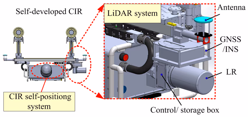
- Position and Orientation System (POS):
- For LiDAR systems that are moving during data acquisition (e.g., mounted on aircraft, drones, or vehicles), knowing the exact position and orientation of the sensor at the moment each laser pulse is emitted and received is crucial.
- This is typically achieved by integrating:
- Global Navigation Satellite System (GNSS) receivers (e.g., GPS, GLONASS): To determine the precise geographic coordinates (X, Y, Z or latitude, longitude, altitude) of the sensor.
- Inertial Measurement Unit (IMU): To measure the sensor's orientation (roll, pitch, and yaw angles).
- For static terrestrial LiDAR scanners (like those Data Capture Service often uses for building documentation), the initial position and orientation are established by known setup points or internal referencing, and multiple scans are registered together using overlapping common features or targets.
- Data Storage and Processing Unit:
- This component records all the raw data generated by the system, including the timing of pulses, intensity values, scanner angle information, and (for mobile systems) POS data.
- Onboard or external computers then perform initial calculations to convert this raw data into a collection of 3D coordinates (X, Y, Z points) that form the "point cloud."
Capture existing conditions with millimeter precision using industry-leading LiDAR systems. Explore our full range of 3D Scanning Services to start building your digital foundation today
The LiDAR Measurement Process: Step-by-Step
The process of acquiring a single 3D point with LiDAR involves these sequential steps:
- A laser pulse is emitted from the laser source.
- The pulse travels through the atmosphere to an object or surface.
- The pulse reflects off the object's surface.
- A portion of the reflected pulse travels back towards the LiDAR sensor.
- The sensor's photodetector records the incoming pulse, noting its time of arrival and often its intensity.
- The scanning mechanism records the precise angle (direction) in which the laser beam was fired.
- If the system is mobile, the POS records the exact 3D position and orientation of the scanner at that instant.
- The system's computer calculates the distance to the point of reflection and then combines this with the angle and POS data to determine the precise 3D coordinates (X, Y, Z) of that point in space.
- This entire process is repeated hundreds of thousands, or even millions, of times per second, with the scanner rapidly redirecting the laser beam to different points. The result is a dense collection of 3D points known as a "point cloud."
Types of LiDAR Systems
LiDAR systems can be categorized in several ways, including their measurement principle and deployment platform:
- Based on Measurement Principle:
- Time-of-Flight (TOF) LiDAR: Measures the direct time it takes for an individual laser pulse to travel to the target and return. This is the most common type, especially for longer-range applications like terrestrial and aerial surveying.
- Phase-Shift LiDAR: Emits a continuous laser beam with a known, modulated phase. It compares the phase of the emitted light wave with the phase of the reflected light wave to calculate the distance. Phase-shift systems can often achieve high accuracy and faster data acquisition rates, typically used for medium-range applications.
- Based on Platform:
- Airborne LiDAR (or Aerial LiDAR): Mounted on aircraft (airplanes, helicopters) or drones (UAVs). Primarily used for large-scale topographic mapping, forestry surveys, and corridor mapping.
- Terrestrial LiDAR (or Ground-Based LiDAR): Typically mounted on a tripod or stationary platform on the ground. Used for detailed scanning of building facades, interiors, industrial plants, accident scenes, and archaeological sites. This is a primary technology used by Data Capture Service.
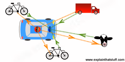
- Mobile LiDAR: Mounted on moving vehicles (cars, trucks, trains, boats) or carried by individuals (handheld or backpack SLAM-based scanners). Allows for rapid mapping of road networks, urban environments, and large indoor spaces.
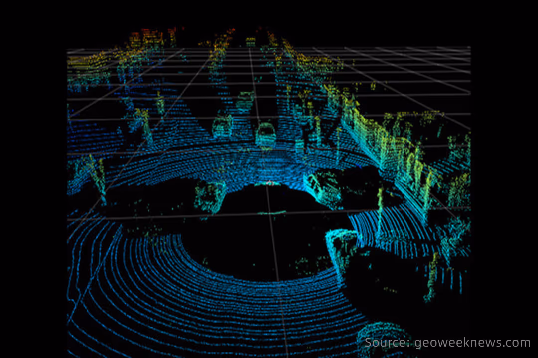
What Information Does LiDAR Provide? The Point Cloud
The primary output of a LiDAR system is a point cloud, which is a vast collection of individual points, each with:
- XYZ Coordinates: Defining its precise location in three-dimensional space.
- Intensity Values: Representing the strength of the reflected laser pulse. The intensity depends on the reflectivity of the surface material at the laser's wavelength. This information can help differentiate between various materials or features (e.g., asphalt vs. concrete, lane markings on a road).
- Color Information (RGB): Many modern LiDAR systems, including advanced instruments like the Leica RTC360 that Data Capture Service utilizes, integrate a digital camera. This camera captures color photographs concurrently with the laser scanning, allowing the point cloud to be "colorized" by assigning RGB values to each point. This creates a photorealistic 3D representation.
- Multiple Returns (for some systems): In applications like forestry or vegetation mapping, a single emitted laser pulse might reflect off multiple surfaces as it travels downwards (e.g., hitting leaves at the top of a tree canopy, then branches further down, and finally the ground). LiDAR systems capable of recording these multiple returns provide valuable data about vegetation structure and ground elevation beneath canopies.
Need clean, ready-to-use layouts for space planning or real estate? Our Floor Plans Services convert scan data into accurate schematic floor plans that support informed decision making.
Why is LiDAR So Effective?
LiDAR's effectiveness stems from several key advantages:
- High Accuracy and Precision: Capable of generating very precise 3D measurements.
- Rapid Data Acquisition: Millions of points can be captured quickly.
- Direct 3D Measurement: It directly measures 3D coordinates, unlike techniques that infer 3D from 2D images.
- Operational Versatility: Can operate in various lighting conditions (day or night) as it's an active sensor (provides its own illumination).
- Vegetation Penetration: The ability of some systems to record multiple returns allows for mapping the ground surface even under dense vegetation.
LiDAR technology, through its sophisticated use of laser light to measure distances, provides an exceptionally powerful and versatile method for creating detailed and accurate three-dimensional maps and models of our world. Its principles enable a vast range of applications where precise spatial data is paramount, and Data Capture Service expertly leverages this technology to deliver high-quality results for diverse client projects.
Want a precise record of how your building actually exists today? Our As-Built Documentation Service delivers detailed CAD and BIM-ready files to support renovations, compliance, and accurate facility management.
Ready to explore in more?
Start here:
.avif)
3 Ways 3D Imaging is Improving Modern Construction

Key Features of Advanced LiDAR Scanners for AEC Workflows
Indoor LiDAR Scanning for Facility Management

Applications of LiDAR in Construction Projects

LiDAR vs Traditional Surveying: Pros and Cons
Prefer to Speak Directly?
Experience precision in every project.
