
LiDAR vs Traditional Surveying: Pros and Cons
LiDAR vs. Traditional Surveying: A Comparative Look at Pros and Cons
For decades, traditional surveying methods have been the cornerstone of accurately measuring and mapping land, structures, and objects. However, the advent and rapid evolution of LiDAR (Light Detection and Ranging) technology have introduced a powerful alternative, offering distinct advantages in many situations. Both approaches aim to capture precise spatial data, but they differ significantly in methodology, speed, data output, and overall capabilities. Understanding the pros and cons of LiDAR versus traditional surveying is crucial for selecting the most effective and efficient approach for specific project needs in the Architecture, Engineering, Construction (AEC) sector and beyond.
Make informed decisions with reliable survey data captured by experienced professionals. Our Building Surveys Services provide thorough assessments of existing conditions for every stage of your project.
Understanding Traditional Surveying Methods
Traditional surveying encompasses a range of established techniques and tools used to measure angles, distances, and elevations to determine the precise location of points on, above, or below the Earth's surface.
- Common Tools and Techniques: This typically involves instruments like:
- Total Stations: Electronic devices that measure angles and distances to a target prism or directly to a surface (reflectorless).
- Theodolites: Optical instruments for measuring horizontal and vertical angles.
- Levels: Used to determine differences in elevation.
- GPS/GNSS Rovers: Satellite-based systems for determining geographic coordinates of specific points.
- Process Overview: Generally, traditional surveying is a point-by-point data collection process. A surveyor manually aims the instrument at specific points of interest, records the measurements, and often takes field notes. This data is then typically used to create 2D drawings, topographic maps, or simple 3D models.
- Key Characteristics: Relies heavily on operator skill and judgment for each measurement, involves direct line-of-sight to targets, and data collection is often sequential and selective.
Understanding LiDAR (Light Detection and Ranging) Surveying
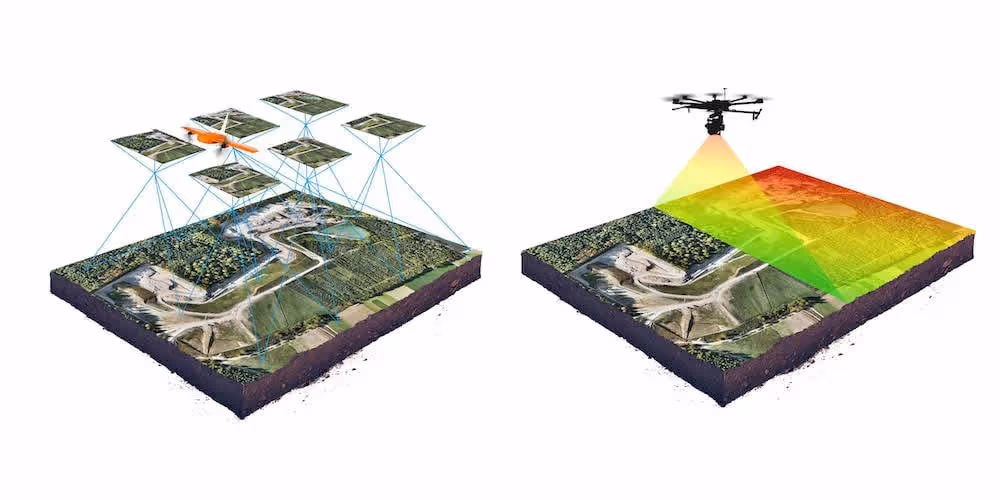
LiDAR is a remote sensing technology that utilizes laser light to rapidly measure variable distances to the Earth or other objects, generating a dense, three-dimensional collection of data points known as a "point cloud."
- Core Principle: A LiDAR scanner emits thousands or millions of laser pulses per second. By measuring the time it takes for these pulses to reflect off surfaces and return to the sensor, the system calculates precise distances. Combined with the scanner's known position and the angle of the laser beam, this information is used to generate XYZ coordinates for each reflection point.
- Process Overview: LiDAR scanning is largely an automated process where the instrument sweeps its laser beam across the area of interest. The resulting point cloud is then processed using specialized software to clean, register (if multiple scans are taken), and extract useful information and deliverables.
- Key Characteristics: It's an active sensor (emits its own light), performs direct 3D measurement, captures exceptionally high data density, and can often be operated remotely or with minimal field intervention during scanning.
Comparing LiDAR and Traditional Surveying
Here's a look at the respective advantages and disadvantages:
Traditional Surveying: Pros
- High Accuracy for Specific, Targeted Points: When properly calibrated and operated by skilled surveyors, traditional instruments like total stations can achieve very high precision for individual, pre-selected points.
- Lower Initial Equipment Cost (for basic setups): The upfront cost for basic traditional surveying equipment (e.g., an optical level or a simple total station) can be lower than that of a professional LiDAR system.
- Established Workflows and Widespread Familiarity: Traditional methods have a long history, meaning procedures are well-established, widely understood, and accepted across the industry.
- Direct Feature Coding and Attribution: Surveyors can often directly code or assign attributes to points as they are collected in the field, which can simplify some downstream data processing tasks.
- Smaller Initial Data Files: Since only discrete points are typically measured, the initial raw data files are much smaller and less demanding on storage and processing power compared to dense LiDAR point clouds.
Traditional Surveying: Cons
- Time-Consuming and Labor-Intensive: The point-by-point data collection process is inherently slow, especially when documenting large, complex areas or intricate structures. This often requires more field personnel and significantly more time on site.
- Limited Data Density and Completeness: Only captures information about the specific points measured. Details and surface variations between these points are missed, often requiring interpolation which can be inaccurate. Comprehensive coverage is difficult to achieve.
- Safety Concerns: Frequently requires surveyors to physically access all areas and points to be measured. This can pose safety risks on active construction sites, unstable terrain, near operational machinery, or in high-traffic areas.
- Potential for Human Error: Heavily reliant on operator skill and diligence for accurate instrument setup, point selection, aiming, reading measurements, and note-taking/data entry.
- Challenging for Complex or Inaccessible Areas: Measuring intricate geometries, congested MEP systems, or dangerous/hard-to-reach locations can be extremely difficult, time-consuming, or practically impossible with traditional methods.
- Strict Line-of-Sight Requirements: Most traditional instruments, like total stations, require an uninterrupted line of sight between the instrument and the measurement point (prism or surface).
Bring your spaces to life with immersive 3D walkthroughs. Use our Virtual Tours Creation Services to showcase properties, enhance stakeholder engagement, and improve remote collaboration.
LiDAR Surveying: Pros
- Exceptional Speed and Efficiency: LiDAR systems acquire data at incredibly high speeds, capturing millions of points in minutes. This dramatically reduces time spent in the field.
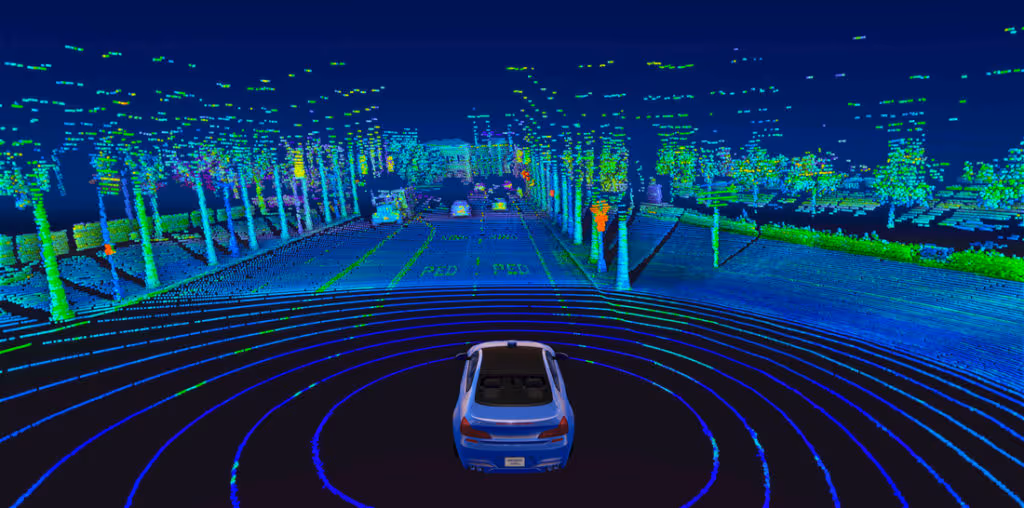
- Comprehensive and Dense Data (High Completeness): Creates a detailed 3D point cloud that represents all visible surfaces within the scanner's range, capturing complex shapes, intricate details, and subtle surface variations often missed by traditional methods.
- High Overall Accuracy and Surface Representation: Provides high geometric accuracy across entire surfaces, not just at pre-selected discrete points, offering a more holistic and accurate representation of reality.
- Enhanced Safety: As a remote sensing technology, LiDAR allows data collection from a safe distance (standoff distance). This significantly reduces the need for personnel to enter hazardous, unstable, or physically inaccessible areas.
- Reduced Human Error in Measurement Collection: The automated nature of data collection minimizes operator-induced errors during the measurement phase.
- Versatility Across Applications: Highly effective for a wide range of environments (interiors, exteriors, large open sites, complex industrial plants) and for producing diverse deliverables (topographic maps, 3D models, as-built documentation, deformation analyses, virtual tours).
- Rich Data Outputs: Point clouds can be colorized with integrated cameras, include intensity values (useful for material differentiation), and serve as a foundation for sophisticated 3D modeling, analysis, and visualization.
LiDAR Surveying: Cons
- Higher Initial Equipment and Software Cost: Professional-grade LiDAR systems and the specialized software required for processing large point cloud datasets represent a more significant upfront investment compared to basic traditional survey tools.
- Large Data File Management: Dense point clouds generate substantial data files that require robust computing hardware for processing, significant storage capacity, and efficient data management strategies.
- Specialized Expertise Required: Operating advanced LiDAR equipment effectively and processing the complex point cloud data to extract meaningful deliverables demands specialized training, skills, and experience.
- Potential for Occlusions (Shadows): Like any optical system, LiDAR requires a clear line of sight to the surfaces it measures. Areas hidden from the scanner's perspective (occlusions or "shadows") will not be captured, often necessitating multiple scan setups to achieve complete coverage.
- Surface Reflectivity Challenges (Less Common with Modern Systems): While advanced LiDAR systems have improved significantly, extremely dark (light-absorbing), highly reflective (mirrored), or transparent surfaces can sometimes pose challenges for data capture quality or accuracy.
- Vegetation Penetration Limitations: While some LiDAR systems (especially certain aerial LiDAR) can achieve partial penetration through vegetation to map the ground beneath, very dense canopies can still limit or prevent ground capture.
When is LiDAR a Better Choice? When Might Traditional Methods Suffice?
The decision often depends on project specifics:
LiDAR surveying excels when:
- Speed, efficiency, and comprehensive data capture are critical: Such as for large sites, complex existing buildings (as-builts), intricate industrial facilities, or projects with tight deadlines.
- Safety is a major concern: When sites are hazardous, inaccessible, or involve active operations.
- High-density 3D data is required for detailed modeling or analysis: Such as for Scan to BIM, creating detailed digital twins, analyzing complex geometries, or performing precise deviation analyses.
- Minimizing disruption to ongoing operations is important.
- A complete and unambiguous record of existing conditions is paramount.
Traditional surveying methods might still be suitable or preferred when:
- Only a few specific, easily accessible points need to be measured with very high precision: For example, establishing initial project control points or very targeted stakeout tasks.
- Budgets are extremely constrained, and the scope of work is very limited and simple.
- The project area is small, open, simple in geometry, and easily accessible.
- A very small number of highly specific features need to be coded by an experienced surveyor in real-time.
Often, a hybrid approach can be most effective, utilizing traditional surveying methods to establish precise ground control networks and then employing LiDAR for the comprehensive and rapid capture of all other site details.
Data Capture Service: Leveraging the Advantages of LiDAR
Data Capture Service specializes in utilizing advanced LiDAR technology to provide clients with the numerous benefits this modern surveying approach offers. By partnering with us, you gain access to the speed, accuracy, completeness, and safety advantages of LiDAR without the substantial investment in equipment, software, and specialized personnel training. We deliver actionable data, including detailed point clouds, precise 2D CAD drawings, and intelligent 3D BIM models, all derived from high-quality LiDAR scans tailored to your project's unique requirements.
While both LiDAR and traditional surveying methods have their specific applications and merits, LiDAR technology presents significant advantages in terms of speed, data comprehensiveness, safety, and overall efficiency for an increasingly wide array of surveying and mapping tasks in the AEC industry and beyond. The choice of method should always be driven by the project's specific goals, accuracy requirements, site conditions, and budget, but the trend clearly indicates a growing reliance on LiDAR for its superior data capture capabilities and the rich insights it provides.
Ready to turn your space into accurate, usable digital assets? Explore our services:
Ready to explore in more?
Start here:
.avif)
3 Ways 3D Imaging is Improving Modern Construction
Key Features of Advanced LiDAR Scanners for AEC Workflows
Indoor LiDAR Scanning for Facility Management
Applications of LiDAR in Construction Projects
How LiDAR Works: Principles Behind Laser-Based Mapping
Prefer to Speak Directly?
Experience precision in every project.
