
Indoor LiDAR Scanning for Facility Management
Optimizing Operations: The Role of Indoor LiDAR Scanning in Facility Management
Effective Facility Management (FM) is crucial for ensuring the efficiency, safety, cost-effectiveness, and overall performance of buildings and infrastructure throughout their operational lifecycle. A primary challenge for FM teams has always been access to accurate, up-to-date information about their facilities. Indoor LiDAR (Light Detection and Ranging) scanning has emerged as a powerful technology that directly addresses this challenge by enabling the creation of precise, detailed digital representations of building interiors, thereby revolutionizing how facilities are managed.
Need highly accurate site data fast? Our 3D Scanning Services capture real-world conditions with millimeter accuracy using the latest LiDAR and reality capture tools.
Challenges in Traditional Facility Management Data
Many FM teams traditionally grapple with data that is:
- Outdated or Inaccurate: Floor plans and as-built drawings are often decades old, may not reflect subsequent renovations or modifications, or contain inaccuracies from original manual drafting.
- Difficult to Access: Information can be scattered across paper documents, various digital files, or institutional memory, making it hard to find when needed quickly.
- Lacking Detail for Hidden Assets: The precise location of concealed pipes, cables, conduits within walls, ceilings, or floors is often unknown or poorly documented.
- Time-Consuming to Verify: Manually collecting data for space audits, asset inventories, or verifying existing conditions for a planned change is a laborious and often disruptive process.
- Leading to Inefficient Planning: Without precise data, planning for space reconfigurations, equipment upgrades, or maintenance can lead to errors, rework, and budget overruns.
How Indoor LiDAR Scanning Works to Capture Interior Spaces
Indoor LiDAR scanning utilizes terrestrial laser scanners specifically designed or adapted for capturing the complex geometries and details of interior environments. The core principle involves:
- Emitting Laser Pulses: The LiDAR unit emits rapid pulses of laser light.
- Measuring Reflections: As these pulses interact with surfaces (walls, floors, ceilings, furniture, equipment), they reflect to the scanner's sensor. The scanner precisely measures the time taken for the light to travel and return (Time-of-Flight) or the phase shift of the returned light.
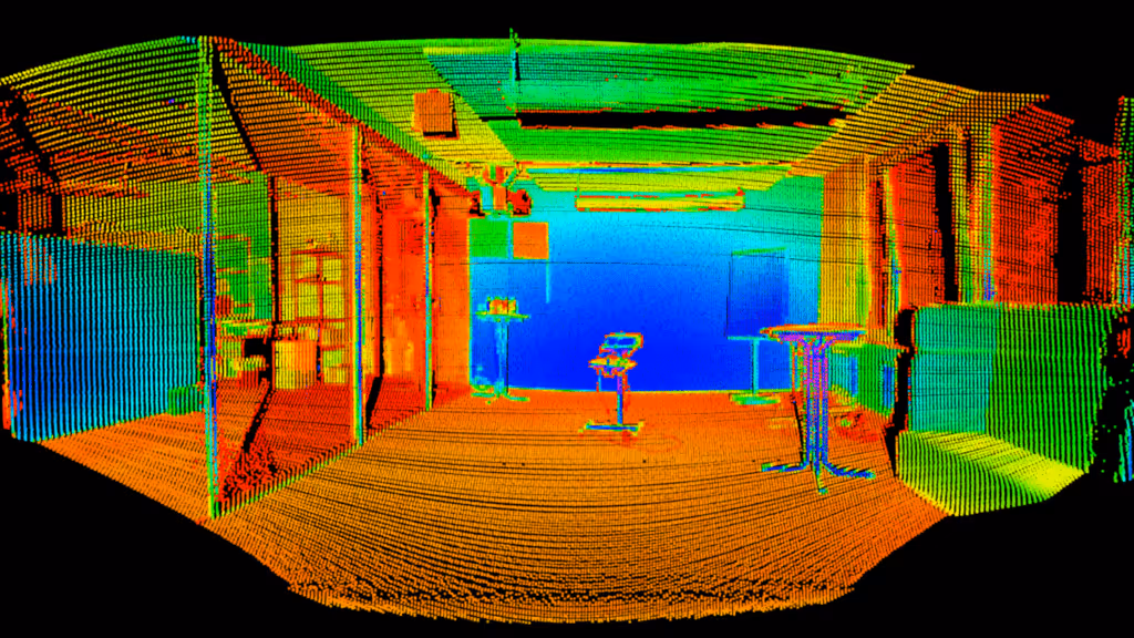
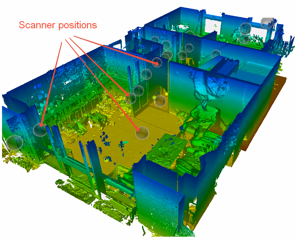
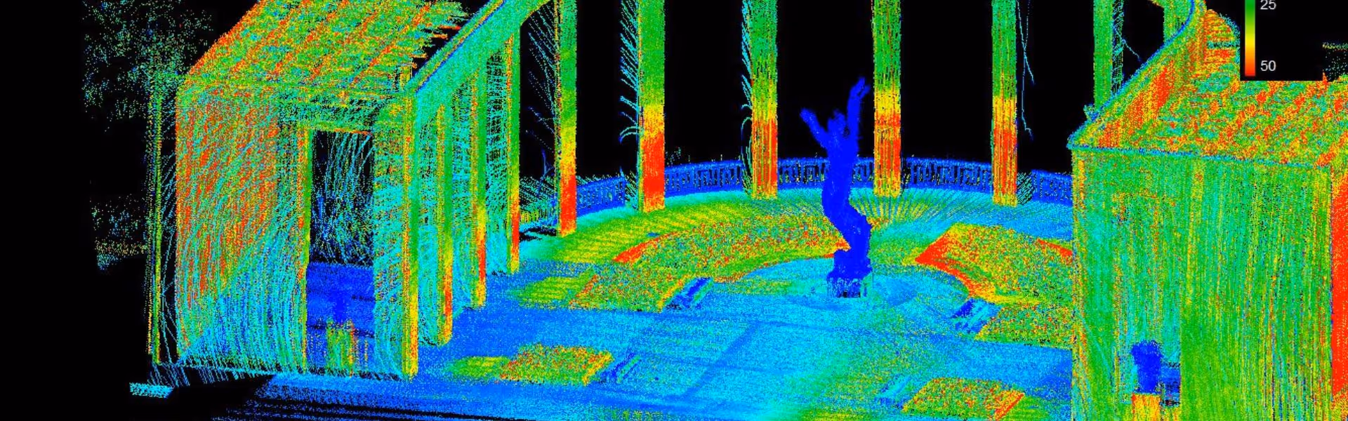
- Creating 3D Point Clouds: Based on these measurements and the known angle of the laser beam, the system calculates millions of 3D coordinates (X, Y, Z points). This dense collection of points forms a "point cloud"—an accurate digital replica of the scanned interior space.
Key characteristics of LiDAR that make it highly suitable for indoor FM applications include its high accuracy (often to within millimeters), its ability to capture intricate details and complex geometries even in cluttered environments, and its relative speed of data acquisition.
Bring your spaces to life with immersive 3D walkthroughs. Use our Virtual Tours Creation Services to showcase properties, enhance stakeholder engagement, and improve remote collaboration.
Key Applications and Benefits of Indoor LiDAR Scanning for FM
The precise 3D point clouds generated by indoor LiDAR scanning serve as the foundation for numerous FM applications and benefits:
- Creation of Highly Accurate As-Built Documentation & Digital Twins:
- Application: Scanning building interiors to generate precise point clouds, which are then used to create or update 2D floor plans, sections, and elevations, or more importantly, to develop detailed 3D As-Built BIM (Building Information Modeling) models through a "Scan to BIM" process.
- Benefits for FM: Provides a reliable, verifiable single source of truth representing the building's current physical state. This eliminates reliance on potentially flawed legacy drawings and forms the accurate geometric foundation for a facility's digital twin, crucial for lifecycle information management.
- Efficient Space Management and Optimization:
- Application: Utilizing accurate scan data to precisely calculate floor areas, room volumes, and analyze current space utilization patterns.
- Benefits for FM: Enables precise space audits and inventories, facilitates better strategic planning for departmental moves or office reconfigurations, helps optimize layouts for improved workflow or occupant density, and provides accurate data for chargeback models or lease agreements.
- Accurate Asset Location, Inventory, and Management:
- Application: LiDAR can capture the precise 3D location of visible fixed and sometimes movable assets (e.g., major equipment, machinery, critical utility components, specialized furniture). This spatial data can be tagged, cataloged, and integrated into FM software or asset databases linked to the BIM model.
- Benefits for FM: Significantly reduces the time spent searching for critical equipment during maintenance or emergencies, improves the accuracy of asset inventories, and streamlines asset tracking and lifecycle management.
- Streamlined Maintenance and Operations Planning:
- Application: Providing maintenance teams with accurate 3D models or virtual tours derived from LiDAR scan data, which can be accessed on desktops or mobile devices.
- Benefits for FM: Allows maintenance staff to easily visualize and understand complex MEP (Mechanical, Electrical, Plumbing) systems and their routing, plan safe and efficient access routes for repairs, remotely assess areas needing attention before a site visit, and reduce errors during maintenance or repair work by having precise contextual information.
- Informed Planning for Renovations, Retrofits, and Equipment Upgrades:
- Application: Using the highly accurate as-built LiDAR data and derived BIM models as the definitive baseline for designing any interior modifications, equipment replacements, or system retrofits.
- Benefits for FM: Ensures that new designs fit perfectly within existing spatial constraints, enables precise clash detection between proposed new elements and existing structures or systems, significantly reduces design rework, and minimizes costly on-site surprises, change orders, and project delays.
- Enhanced Safety and Emergency Preparedness Planning:
- Application: Creating accurate 3D models that clearly map out egress routes, the location of safety equipment (fire extinguishers, alarm panels, first aid stations), and the overall building layout.
- Benefits for FM: Facilitates the development and validation of more accurate emergency evacuation plans, helps in planning optimal access routes for first responders, provides clear visual aids for safety training, and ensures precise documentation of safety zones and equipment locations.
- Improved Documentation for Compliance and Reporting:
- Application: Using precise scan data to verify critical dimensions, clearances, accessibility features, and layouts against building codes, accessibility standards (e.g., ADA), or other regulatory requirements.
- Benefits for FM: Provides accurate, verifiable documentation for compliance audits, supports insurance assessments, and can be used to validate lease agreements regarding space provisions.
Key Considerations for Indoor LiDAR Scanning in FM
To maximize the benefits of indoor LiDAR scanning for facility management:
- Define Level of Detail (LOD) / Level of Information Need (LOIN): Clearly specify how much geometric detail and what types of information need to be captured and included in the final models, based on intended FM uses.
- Data Integration Strategy: Plan how the scan data and derived models will integrate with existing FM software platforms, such as Computerized Maintenance Management Systems (CMMS), Computer-Aided Facility Management (CAFM), or Integrated Workplace Management Systems (IWMS).
- Frequency of Scans: Determine if the facility is dynamic enough to warrant periodic rescans to keep the digital twin updated with significant changes or for ongoing condition monitoring.
- Site Logistics: Plan scanning activities to minimize disruption in occupied and operational facilities, considering factors like accessibility, line-of-sight obstructions, and coordination with building occupants.
Data Capture Service: Your Partner for Indoor LiDAR Solutions
Data Capture Service specializes in utilizing advanced indoor LiDAR scanning technology, including state-of-the-art Leica scanners like the BLK360 and RTC360. We have the expertise to accurately capture complex interior environments and deliver a range of outputs tailored to your facility management needs. These include:
- Precise, registered point clouds.
- Accurate 2D CAD drawings (floor plans, sections, elevations).
- Detailed As-Built 3D BIM models, ready for integration into your FM workflows.
We are committed to helping facility management teams build a reliable digital foundation, enabling them to optimize their operations, make data-driven decisions, and enhance the overall performance and longevity of their buildings.
Indoor LiDAR scanning offers a transformative approach to capturing the accurate spatial data that is essential for modern, efficient facility management. It empowers FM teams with superior information, leading to optimized building operations, significant cost savings, enhanced safety, and improved strategic planning throughout the entire lifecycle of a facility.
Ready to explore in more?
Start here:
.avif)
3 Ways 3D Imaging is Improving Modern Construction
Key Features of Advanced LiDAR Scanners for AEC Workflows
Applications of LiDAR in Construction Projects
LiDAR vs Traditional Surveying: Pros and Cons
How LiDAR Works: Principles Behind Laser-Based Mapping
Prefer to Speak Directly?
Experience precision in every project.
