
Comparing 3D Scanners: Photogrammetry vs Laser
Comparing 3D Capture Technologies: Photogrammetry vs. Laser Scanning (LiDAR)
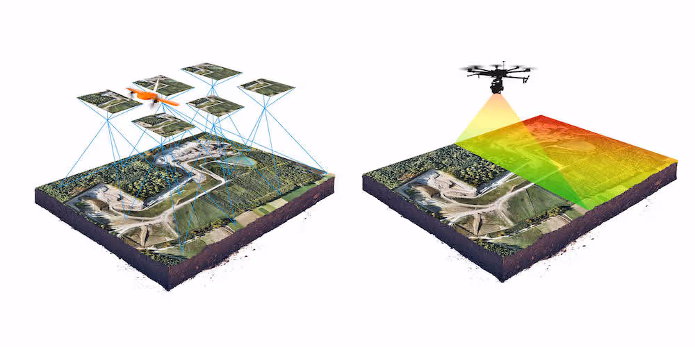
Creating accurate 3D models of real-world objects, buildings, and environments is crucial in many industries, especially Architecture, Engineering, and Construction (AEC). Two dominant technologies for this reality capture are photogrammetry and laser scanning (commonly referred to as LiDAR). While both aim to produce digital 3D representations, they operate on fundamentally different principles and possess distinct advantages, limitations, and ideal use cases. Understanding these differences is key to selecting the most effective approach for a specific project's needs.
If you already have point cloud data but need it transformed into intelligent BIM assets, our Scan to BIM Services are the perfect next step. We generate coordinated, Revit-ready models that support clash detection, design validation and digital twin creation.
Understanding Laser Scanning (LiDAR)
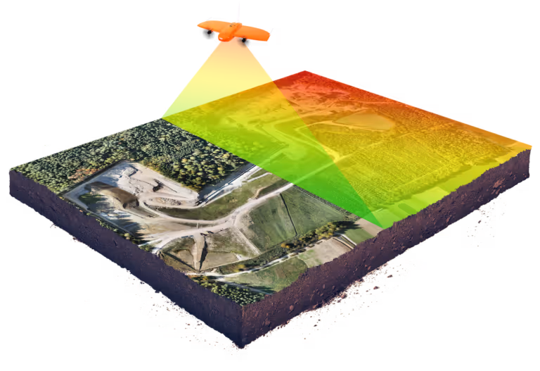
LiDAR (Light Detection and Ranging) is an active remote sensing method. It works by emitting pulses of laser light towards a target surface and measuring the time it takes for these pulses to reflect and return to the sensor. By knowing the speed of light and the precise time of flight (or phase shift in some systems), the LiDAR unit calculates the exact distance to millions of points on the target surfaces.
- Key Characteristics:
- Active Sensor: It generates its own light source (laser), making it largely independent of ambient lighting conditions.
- Direct Measurement: It directly measures the 3D coordinates (X,Y,Z) of points on a surface.
- High Geometric Accuracy: LiDAR is renowned for its ability to capture highly accurate and precise geometric data.
- Dense Point Clouds: Modern LiDAR scanners rapidly acquire millions of individual measurement points, forming a detailed "point cloud."
- Strengths:
- High Accuracy and Precision: Delivers reliable, survey-grade accuracy for geometric measurements.
- Effective in Varied Lighting: Can operate effectively in low light, complete darkness, or even some challenging bright light conditions.
- Long Range Capabilities: Many terrestrial LiDAR systems can scan objects and environments from significant distances (tens to hundreds of meters, or even further for specialized systems).
- Excellent for Complex Geometries: Captures intricate details and complex shapes with high fidelity.
- Vegetation Penetration: Some LiDAR systems (especially those with multiple return capabilities) can "see" through vegetation to measure the ground surface beneath.
- Limitations/Considerations:
- Equipment Cost: High-end LiDAR scanners can represent a significant capital investment, which can influence service costs.
- Surface Properties: Highly reflective (mirror-like) or transparent (glass) surfaces can sometimes be challenging for lasers to capture accurately without special techniques, though modern systems have improved significantly. Very dark, light-absorbing surfaces can also reduce effective range or data quality.
- Large Data Files: The dense point clouds generated can result in very large file sizes, requiring robust computing power for processing.
- Color Data Acquisition: While many modern LiDAR scanners integrate high-quality cameras to colorize point clouds (like the Leica systems Data Capture Service uses), the color information is technically captured by a separate sensor (the camera) and mapped to the LiDAR points.
- Common AEC Uses:As-built surveys and documentation, construction verification, Scan to BIM, topographic mapping, deformation monitoring, industrial metrology, heritage preservation, and infrastructure surveys.
Understanding Photogrammetry
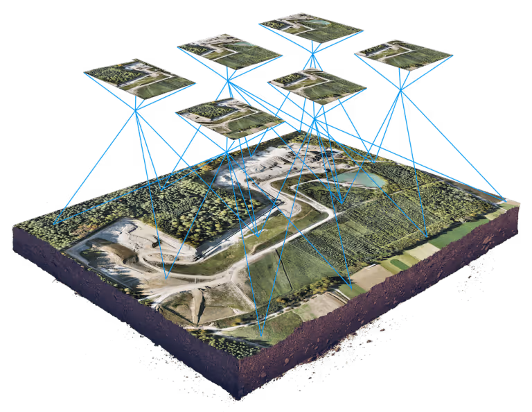
Photogrammetry is the science and technology of obtaining reliable information about physical objects and the environment through the process of recording, measuring, and interpreting photographic images and patterns of electromagnetic radiant imagery and other phenomena. In essence, it uses sophisticated software to analyze multiple overlapping photographs of an object or scene, taken from various angles, to reconstruct its 3D geometry.
- Key Characteristics:
- Passive Sensor: It relies on ambient light (sunlight or artificial lighting) to illuminate the subject.
- Indirect Measurement: 3D geometry is calculated from 2D images by identifying and matching common features across multiple photographs.
- Rich Texture and Color: Inherently captures high-resolution color and texture information directly from the photographs.
- Strengths:
- Cost-Effectiveness (Hardware): Can utilize readily available, high-quality digital cameras, including DSLRs, mirrorless cameras, and even cameras on drones or smartphones for certain applications, potentially leading to lower initial hardware costs.
- Excellent for Realistic Visuals: Produces 3D models with photorealistic color and texture, making them ideal for visualization purposes.
- Flexible Deployment: Cameras can be deployed in various ways (handheld, tripod-mounted, vehicle-mounted, drone-mounted), offering high flexibility.
- High Accuracy Potential: With careful methodology—including using a high-quality calibrated camera, ensuring sufficient image overlap, maintaining consistent lighting, using surveyed Ground Control Points (GCPs), and employing robust processing software—photogrammetry can achieve very high levels of accuracy.
- Limitations/Considerations:
- Lighting Dependency: Highly sensitive to lighting conditions. Consistent, even illumination is crucial. Strong shadows, glare, or rapidly changing light can significantly impact data quality.
- Surface Challenges: Struggles with textureless, plain, highly reflective, or transparent surfaces because the software needs distinct, recognizable features to match across images.
- Variable Accuracy: Accuracy is heavily dependent on the entire capture workflow (camera quality, image network geometry, GCPs, processing). Achieving high global accuracy often requires significant effort in ground control.
- Processing Intensity: Processing large sets of high-resolution images can be computationally demanding and time-consuming.
- Scale Ambiguity: Without known distances or GCPs, determining the absolute scale of the model can be challenging.
- Common AEC Uses:Creating visually rich textured 3D models for presentations, aerial mapping and site surveys (especially with drones), documenting building facades and architectural details, creating virtual tours (systems like Matterport often combine photogrammetry with depth sensors), and cultural heritage documentation.
Accurate decisions start with accurate data. Our 3D Scanning Services use high-precision LiDAR and reality capture technologies to document real-world conditions at millimeter accuracy—ideal for design, verification, and compliance.
When to Choose Which? Or Use Both?
The decision between laser scanning and photogrammetry (or a combination) depends on the specific project requirements:
Choose Laser Scanning (LiDAR) when:
- The highest possible geometric accuracy and precision are critical (e.g., for precise as-builts, deformation analysis, industrial metrology).
- Working in environments with poor, inconsistent, or no ambient lighting.
- Long-range data capture is necessary.
- The primary goal is to capture complex, non-textured geometries with high fidelity.
- Some degree of vegetation penetration is needed (using multi-return LiDAR).
Choose Photogrammetry when:
- The primary goal is to create high-resolution, photorealistic 3D models with accurate color and texture (e.g., for visualizations, virtual reality, or digital archiving of artifacts).
- The budget for initial capture hardware is a significant constraint (though professional services and processing software still have costs).
- Aerial mapping of large areas is required (drone photogrammetry is very efficient for this).
- Flexibility in deployment (e.g., using existing camera equipment or drones) is key.
Hybrid Approaches (The Best of Both Worlds):Increasingly, workflows are emerging that combine the strengths of both LiDAR and photogrammetry:
- LiDAR for Geometry, Photogrammetry for Texture: A common approach is to use LiDAR to capture the accurate geometric framework (point cloud) and then overlay high-resolution textures derived from photogrammetrically processed images onto the LiDAR-derived model. This yields both geometric accuracy and visual realism.
- Integrated Systems: Some capture devices, like certain Matterport cameras, effectively use a hybrid approach by combining photogrammetry with infrared depth sensors (a simpler form of active sensing than survey-grade LiDAR) to create visually rich and spatially coherent 3D tours.
Data Capture Service: Expertise in Selecting the Right Tool
At Data Capture Service, we understand the distinct capabilities and nuances of both laser scanning and photogrammetry-based systems. We utilize:
- Advanced Laser Scanners (e.g., Leica Geosystems): When projects demand the highest level of geometric accuracy and reliability for applications like Scan to BIM, detailed as-built surveys, and construction verification.
- Systems Leveraging Photogrammetry and Depth Sensing (e.g., Matterport Pro series): For creating immersive 3D virtual tours, efficient visual documentation, and when rich visual context is paramount.
Our approach involves a thorough assessment of your project's specific objectives, required accuracy, site conditions, and desired deliverables. This allows us to deploy the most appropriate technology, or a combination of technologies, to ensure you receive the best possible data quality and outcomes.
Both laser scanning (LiDAR) and photogrammetry are powerful and valuable 3D capture technologies, each with a unique set of strengths and ideal applications. The choice between them, or the decision to use a hybrid approach, depends heavily on the specific goals of the project. An understanding of their core differences empowers AEC professionals and other stakeholders to make more informed decisions when planning reality capture for their projects.
Ready to turn your space into accurate, usable digital assets? Explore our top rated services:
- As-Built Documentation Services
- Scan to BIM Services
- 3D Scanning Services
- Floor Plans Creation Services
- Building Surveys Services
- Virtual Tours Creation Services
Ready to explore in more?
Start here:
Benefits of 3D Scanning for Historical Preservation
3D Scanning for Manufacturing & Product Design
The Role of 3D Scanning in As-Built Documentation
Matterport 3D Scanning for Real Estate and Beyond

Building Information Modeling (BIM) with 3D Scanning
The Role of 3D Scanning in As-Built Documentation
Building Information Modeling (BIM) with 3D Scanning
Matterport 3D Scanning for Real Estate and Beyond
Prefer to Speak Directly?
Experience precision in every project.
