
The Role of 3D Scanning in As-Built Documentation
The Critical Role of 3D Scanning in Modern As-Built Documentation
As-built documentation is a cornerstone of any successful construction, renovation, or infrastructure project. It serves as the official, factual record of a facility as it was actually constructed, capturing deviations from the original design and providing a precise snapshot of its final state. The quality of this documentation profoundly impacts lifecycle management, future modifications, and operational efficiency. In this context, 3D scanning technology has emerged not merely as an alternative but as a transformative force, playing an indispensable role in creating as-built records that are vastly more accurate, comprehensive, and useful than those produced by traditional methods.
Need highly accurate 2D plans and elevations from your scan data? Our As-Built Documentation Service delivers precise drawings and models tailored to your specifications.
The Shortcomings of Traditional As-Built Documentation Approaches
To fully appreciate the pivotal role of 3D scanning, it's useful to briefly recall the limitations inherent in older, manual methods of producing as-builts:
- Inaccuracies and Errors: Manual field measurements are susceptible to human error, misinterpretation, and transcription mistakes, leading to as-built documents that may not truly reflect reality.
- Incompleteness: It is often impractical or too time-consuming to manually capture every detail, especially in complex, congested, or hard-to-reach areas. This frequently results in significant omissions.
- Time-Intensive Nature: The process of manual measurement, note-taking, red-lining drawings, and then transferring that information into final documents is extraordinarily slow and labor-intensive.
- Legibility and Consistency: Hand-drawn markups can suffer from poor legibility, inconsistent notations, and varying standards, making them difficult to use reliably.
- Delayed Availability: The lengthy process often means that final as-built documentation is not available until long after project completion, hindering immediate facility management needs.
These issues historically diminished the trustworthiness and overall utility of as-built documentation.
3D Scanning: The Foundation for Trustworthy As-Builts
The fundamental role of 3D scanning in as-built documentation is to provide an objective, comprehensive, and exceptionally accurate digital representation of the physical reality of a constructed asset at a specific point in time. It serves as the primary data capture mechanism that underpins the creation of modern, reliable as-built records.
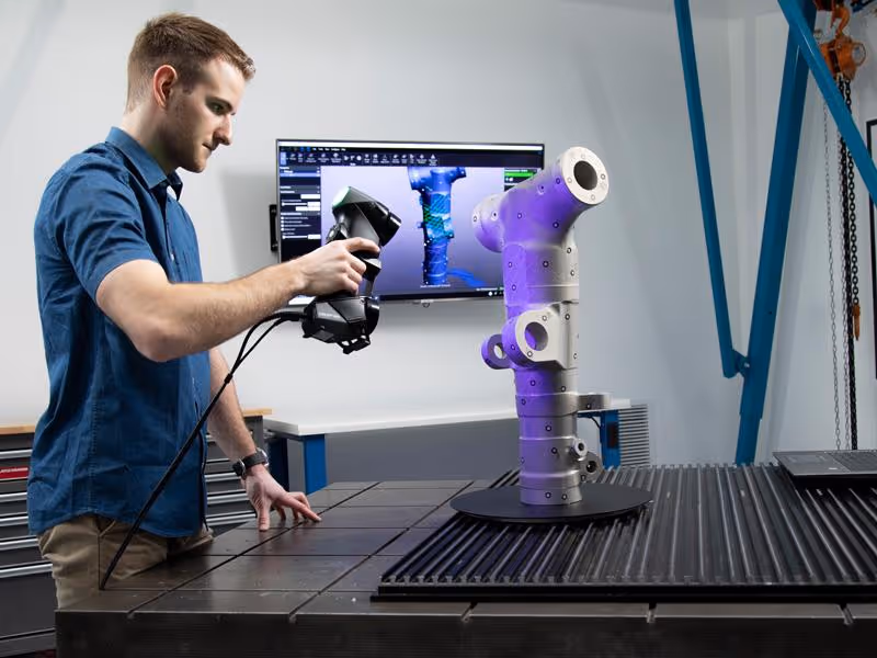
Key technologies like LiDAR (Light Detection and Ranging) and advanced photogrammetry (including integrated systems like Matterport that combine photogrammetry with depth sensing) are the principal enablers. These tools rapidly capture millions, or even billions, of precise measurement points from the surfaces of an object or environment. The direct output of this process is a rich, three-dimensional "point cloud," which forms the foundational dataset from which all accurate as-built information is derived.
Ensure full spatial coverage and millimeter-level accuracy with our professional 3D Scanning Services, powered by industry-leading LiDAR technologies.
Exploring the Multifaceted Roles and Impacts of 3D Scanning
3D scanning plays several interconnected and critical roles in enhancing the as-built documentation process, each with a significant positive impact:
- Establishing Unmatched Accuracy and Precision:
- Role: To serve as the definitive and verifiable source of precise geometric data for all elements included in the as-built documentation.
- Impact: This technology dramatically minimizes, and in many cases entirely eliminates, the human errors associated with manual measurement techniques. Depending on the specific 3D scanning system and project requirements, it can deliver millimeter to centimeter-level accuracy. This ensures that the final as-built documentation is a true and faithful representation of the actual dimensions, locations, and orientations of all captured building components.
- Ensuring Comprehensive Coverage and Data Completeness:
- Role: To deliver a complete and detailed spatial inventory of all visible components and features within the scanned area or structure.
- Impact: The dense point clouds generated by 3D scanners capture intricate details, complex geometries (like curved surfaces or ornate features), and elements within congested spaces (such as dense MEP systems above ceilings or in plant rooms) that are frequently missed, oversimplified, or impossible to document accurately using manual methods. This high level of completeness significantly reduces the risk of costly omissions in the as-built record.
- Accelerating the On-Site Data Collection Phase:
- Role: To rapidly acquire vast quantities of detailed as-built data with minimal disruption to ongoing site activities or facility operations.
- Impact: Compared to traditional manual surveying methods for achieving a comparable level of detail, 3D scanning drastically reduces the time required for on-site field verification and data collection. This allows for faster turnaround in capturing existing conditions, enabling quicker updates to documentation throughout a project or more frequent monitoring if needed.
- Elevating the Quality and Reliability of Final As-Built Deliverables:
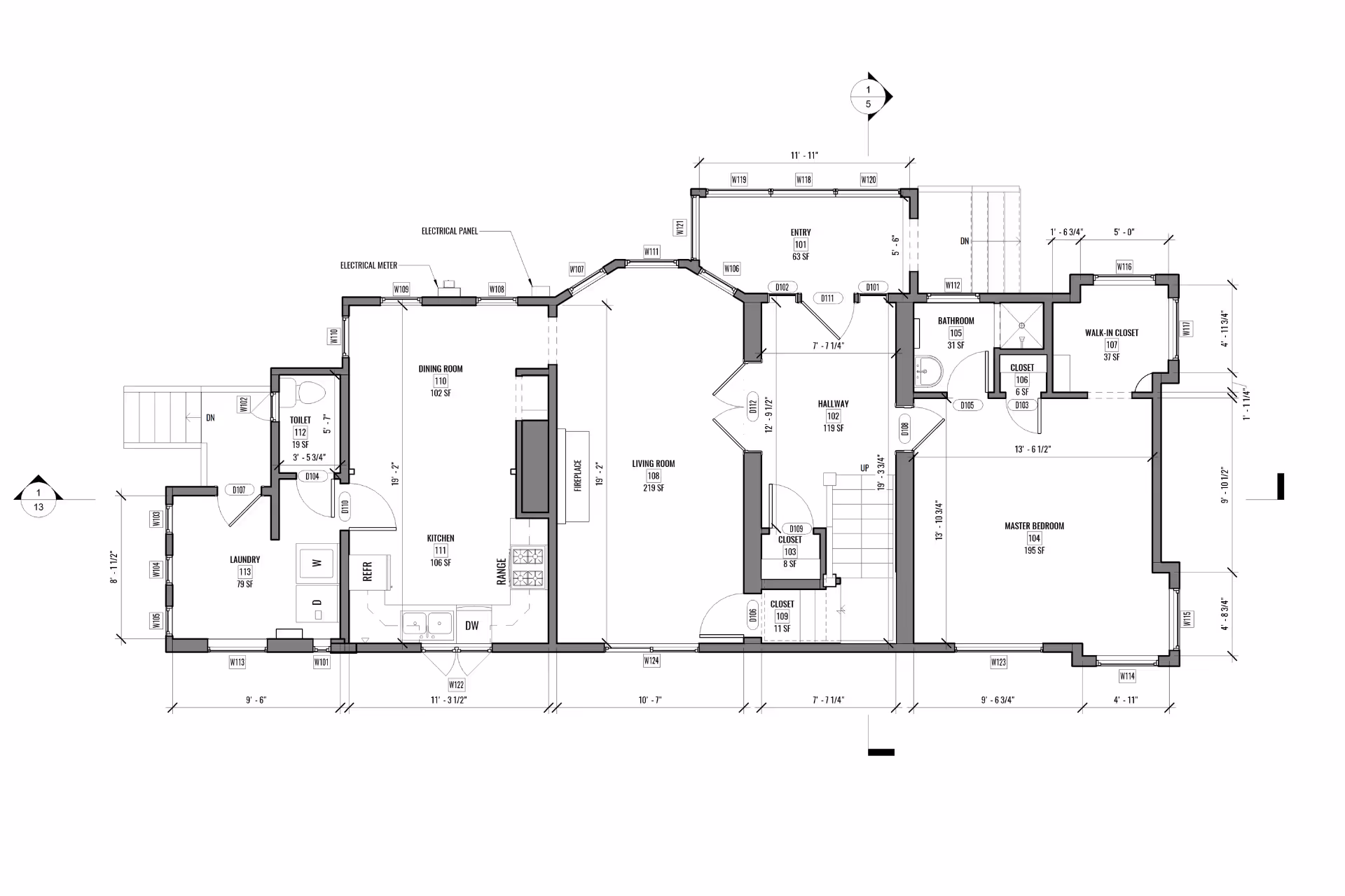
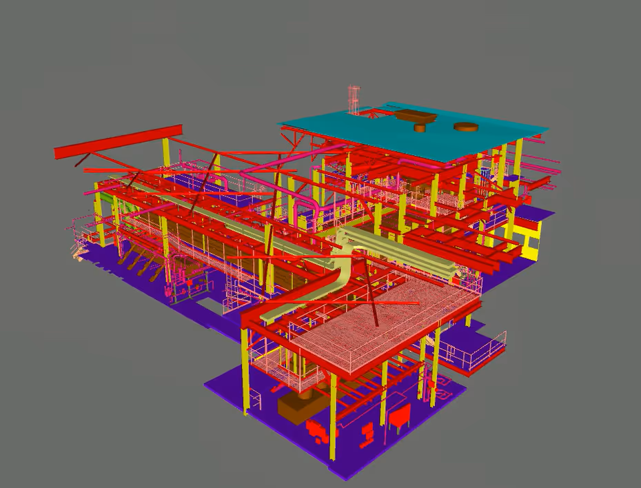
- Role: To act as the direct, verifiable, and traceable digital foundation for producing all forms of subsequent as-built documentation. This includes highly accurate 2D drawings (through a "Scan to CAD" process) and intelligent 3D BIM models (through a "Scan to BIM" process).
- Impact: Because these crucial deliverables are derived from precise and comprehensive scan data, they are inherently more trustworthy and reliable than documents based on manual interpretations, incomplete field notes, or potentially flawed red-line markups. This instills greater confidence in the as-built documentation for all its intended uses.
- Enhancing Safety During Field Data Acquisition:
- Role: To provide a significantly safer methodology for documenting environments that are challenging, potentially hazardous, or physically inaccessible to personnel.
- Impact: Most 3D scanners possess remote sensing capabilities, allowing data capture from a safe standoff distance. This minimizes or eliminates the need for personnel to enter unstable structures, confined spaces, areas with active machinery, or work at dangerous heights.
- Fostering Improved Collaboration and Clearer Communication:
- Role: To serve as a common, unambiguous visual and metric reference point for all project stakeholders, including contractors, designers, engineers, clients, and future facility operators.
- Impact: The digital nature of 3D scan data—point clouds, derived 3D models, and immersive virtual tours—facilitates easier sharing, better understanding of complex conditions, reduced misinterpretations, and more effective collaborative decision-making throughout the project and into the operational phase.
- Creating a Permanent, Verifiable Digital Archive for Lifecycle Management:
- Role: To establish an accurate and enduring digital foundation that meticulously represents the building's state at a specific point in time, thereby supporting its entire operational lifespan and beyond.
- Impact: The point cloud itself constitutes a valuable, permanent digital snapshot that can be archived and revisited for future reference or analysis. As-built models derived from this data are crucial for effective long-term facility management, informed planning for future renovations or retrofits, and the development of comprehensive digital twins.
- Supporting Tailored Levels of Detail (LOD) in As-Built Outputs:
- Role: To offer the inherent flexibility needed to generate as-built documentation that precisely meets diverse project requirements and varying levels of information need (LOIN).
- Impact: The intrinsically rich and dense data captured by 3D scanners allows for the creation of as-built documentation at various Levels of Detail (LOD). This can range from basic building layouts and massing models to highly detailed and specific models accurately representing particular systems, components, or intricate architectural features, precisely as required by the end-user for their specific purpose.
The Workflow: From 3D Scan Data to Final As-Built Documentation
The process where 3D scanning underpins the creation of robust as-built documentation typically involves:
- Strategic Scan Planning: Defining the project scope, required accuracy levels, areas to be captured, and desired final deliverables.
- Precise On-Site 3D Scanning: Utilizing appropriate LiDAR, structured light, or photogrammetry-based scanning technology to capture the comprehensive point cloud data.
- Rigorous Point Cloud Registration and Processing: Cleaning, filtering, and accurately aligning multiple scans into a single, cohesive, and georeferenced point cloud.
- (Optional) Direct Point Cloud Deliverable: The registered, cleaned point cloud itself can be a valuable as-built deliverable for certain applications.
- Skilled Modeling and Drafting: Using the point cloud as a highly accurate reference to create:
- Scan to CAD: Precise 2D as-built drawings (floor plans, elevations, sections).
- Scan to BIM: Intelligent 3D As-Built BIM models with accurate geometry and potentially embedded asset data.
- Thorough Quality Assurance: Verifying the accuracy and completeness of all derived as-built documentation against the source point cloud data and project specifications.
- Delivery of Final As-Built Documentation: Providing the client with the finalized, accurate, and usable as-built records in the required formats.
Throughout this workflow, the integrity and precision of the initial 3D scan data are fundamental, as they directly influence the quality of all subsequent deliverables.
Want to visualize and share existing conditions with stakeholders in an immersive format? Try our Virtual Tours Creation Services to build intuitive, navigable digital twins of your site.
Data Capture Service: Your Partner for 3D Scan-Driven As-Builts
At Data Capture Service, we specialize in harnessing the full potential of 3D scanning technology to produce superior as-built documentation. Our expertise encompasses:
- Employing a range of advanced 3D scanning equipment, including high-precision LiDAR systems (such as those from Leica Geosystems) and versatile Matterport cameras, to select the optimal tool for your project's specific requirements.
- Leveraging skilled technicians for meticulous on-site data acquisition and rigorous, accurate point cloud processing.
- Proficiency in transforming raw scan data into high-quality, precise as-built deliverables, including industry-standard point cloud formats, AutoCAD drawings (DWG), and detailed, intelligent Revit BIM models (RVT).
We are dedicated to ensuring that 3D scanning effectively fulfills its critical role in your as-built documentation strategy, providing you with records that are not just documents, but valuable, actionable assets.
The role of 3D scanning in creating modern as-built documentation is no longer an emerging trend but a firmly established best practice within the AEC industry and beyond. By offering an unparalleled method for capturing existing reality with exceptional speed, accuracy, and completeness, 3D scanning fundamentally elevates the standards, reliability, and overall utility of as-built records. This crucial contribution is vital for mitigating project risks, reducing lifecycle costs, ensuring safety, and maximizing the long-term value and effective management of all built assets.
Ready to explore in more?
Start here:
Comparing 3D Scanners: Photogrammetry vs Laser
Benefits of 3D Scanning for Historical Preservation
3D Scanning for Manufacturing & Product Design
The Role of 3D Scanning in As-Built Documentation
Matterport 3D Scanning for Real Estate and Beyond

Building Information Modeling (BIM) with 3D Scanning
Building Information Modeling (BIM) with 3D Scanning
Matterport 3D Scanning for Real Estate and Beyond
Prefer to Speak Directly?
Experience precision in every project.
