
How Accurate Is 3D Scanning? Margin of Error Explained
How Accurate Is 3D Scanning? Understanding Precision and Margin of Error
When considering 3D scanning for any project, whether it's for creating as-built documentation, construction verification, industrial inspection, or historical preservation, one of the most critical questions is: "How accurate is it?" The answer is that 3D scanning technology can be exceptionally accurate, but its precision is not a single, fixed value. It varies significantly based on the specific technology used, the quality of the equipment, the scanning procedures, environmental conditions, and the nature of the object or site being scanned. This page explores the factors that influence 3D scanning accuracy and typical margins of error you might expect.
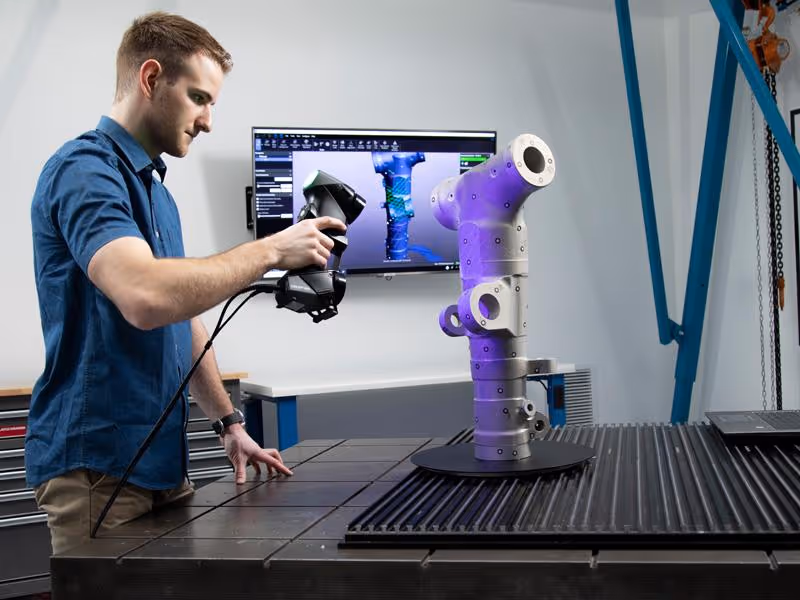
Accurate decisions start with accurate data. With our 3D Scanning Services, we deploy advanced LiDAR scanners (such as Leica RTC360 and BLK series) to capture millions of measurement points from even complex or congested environments — producing reliable point clouds for use in CAD/BIM workflows, verification reports, and digital twins.
Defining Accuracy in 3D Scanning
Before diving into numbers, it's helpful to understand a few key terms:
- Accuracy: Refers to how close a measured value (from the 3D scanner) is to the true, actual physical value of the object or environment. High accuracy means the scan data faithfully represents reality.
- Precision (or Repeatability): Describes how close repeated measurements are to each other when taken under the same conditions. A scanner can be precise (consistent results) without necessarily being accurate (close to the true value), though ideally, a good system is both.
- Resolution: Relates to the smallest detail or feature that a scanner can detect and capture. Higher resolution means more data points and the ability to capture finer details.
While all three are important, clients are often most concerned with overall system accuracy – how well the final 3D data or model represents the real-world subject.
Factors Influencing 3D Scanning Accuracy
Several key factors contribute to the final accuracy of 3D scan data:
- Scanning Technology Used:
- LiDAR (Light Detection and Ranging):
- Terrestrial LiDAR Scanners (Static): These are generally among the most accurate for architectural and engineering applications. High-end systems, like those from Leica Geosystems (which Data Capture Service utilizes), can achieve accuracies ranging from sub-millimeter (for specialized metrology scanners) to a few millimeters (e.g., ±2mm to ±6mm at typical ranges like 10-25 meters) for individual point measurements. The overall accuracy of a registered point cloud composed of multiple scans depends on the registration process.
- Mobile LiDAR Scanners (SLAM-based): These systems, often handheld or mounted on vehicles/drones, use SLAM (Simultaneous Localization and Mapping) algorithms to track their position while scanning. While incredibly efficient for rapid mapping, their accuracy is generally slightly lower than static terrestrial LiDAR, often in the range of ±1cm to ±5cm, depending on the system and environment.
- Aerial LiDAR: Used for large-scale topographic mapping, the accuracy is influenced by flight altitude, sensor quality, and GPS/IMU precision, typically ranging from a few centimeters to tens of centimeters.
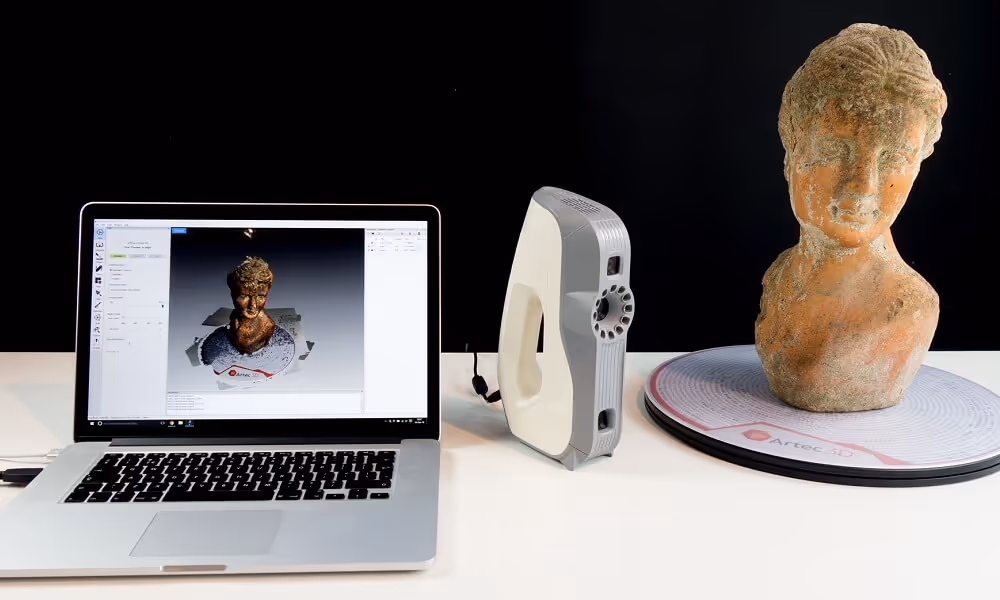
- Structured Light Scanning: This technology projects patterns of light onto an object and analyzes their deformation. It can achieve very high accuracy (sub-millimeter, even into the micron range for metrology-grade systems) for smaller objects at relatively close ranges. Accuracy tends to decrease as the scanning volume or range increases.
- Photogrammetry: This technique derives 3D information from multiple overlapping photographs. Its accuracy is highly variable and depends on factors like camera resolution, lens quality, the number and geometry of photos, the stability of the camera, the use of calibrated scale bars and Ground Control Points (GCPs), and the sophistication of the processing software. It can range from sub-millimeter for controlled, close-range object scanning to several centimeters or more for large-scale aerial or terrestrial mapping without robust ground control. Integrated systems like Matterport, which use a combination of cameras and sometimes depth sensors, often quote a dimensional accuracy of around ±1% of the measured dimension for their spatial data.
- LiDAR (Light Detection and Ranging):
- Scanner Specifications and Quality:
- Manufacturers provide specifications for their scanners, including range noise (point cloud "thickness"), angular accuracy, beam divergence (for LiDAR), and single-point accuracy under ideal conditions.
- Regular calibration and maintenance of the scanning equipment are crucial for maintaining its stated accuracy.
- The quality of optical components (lenses, mirrors) and mechanical systems within the scanner also plays a significant role.
- Scanning Procedure and Best Practices:
- Scan Planning: Proper planning, including determining the optimal number and placement of scan setups to ensure sufficient overlap and coverage, is critical for accurate registration.
- Targets and Ground Control: Using physical targets or surveyed Ground Control Points (GCPs) can significantly improve the global accuracy of a registered point cloud, tying it to a known coordinate system.
- Stability: Ensuring the scanner is on a stable tripod or platform during static scans is essential to prevent motion blur or misalignment.
- Operator Skill: Experienced operators understand how to optimize scanner settings, plan scan strategies effectively, and mitigate environmental challenges.
- Object and Environmental Characteristics:
- Surface Properties: Highly reflective (shiny metallic), transparent (glass), or very dark (light-absorbing) surfaces can be challenging for optical scanners and may result in noisy or less accurate data. Special techniques or sprays might be needed.
- Vibrations and Movement: Any movement of the object being scanned or vibrations affecting the scanner during acquisition will degrade accuracy.
- Environmental Conditions: Temperature fluctuations, humidity, dust, and even ambient light can affect some scanning technologies.
- Data Processing Software and Algorithms:
- The quality of the algorithms used in the processing software for registering multiple scans, filtering noise, and creating meshes or models significantly impacts the final accuracy of the deliverables.
- If the end product is a BIM model created from the point cloud (Scan to BIM), the skill of the modeler in accurately interpreting and representing the point cloud data also contributes to the final as-built model's accuracy relative to the scan.
Already have point clouds but need intelligent project-ready models? Our Scan to BIM Services translate raw reality capture data into clean, structured Revit models that support design coordination, clash detection, digital twinning, and asset tracking across the building lifecycle.
Typical Margins of Error for Common Applications
It's important to match the scanning technology and methodology to the accuracy requirements of the project:
- Architectural As-Builts (using Terrestrial LiDAR): Overall building dimensions and major features can often be captured with an accuracy of ±5mm to ±15mm. For specific critical elements, higher precision is achievable.
- Construction Verification (using Terrestrial LiDAR): Checking elements like floor flatness, column plumbness, or slab edge locations can often achieve accuracies of ±3mm to ±10mm.
- Industrial Metrology & Reverse Engineering (using high-end LiDAR or Structured Light): These applications often demand sub-millimeter accuracy, potentially in the ±0.02mm to ±0.5mm range.
- Topographic & Large Site Surveys (using Aerial or Terrestrial LiDAR): Accuracies might range from ±2cm to ±10cm, depending on the scale, terrain, and equipment.
- Interior Space Mapping for Virtual Tours (e.g., Matterport Pro series): While excellent for visual representation and general layout, dimensional accuracy is typically around ±1% of the measured distance. This is suitable for many visualization and basic planning tasks but not for engineering-grade precision requiring sub-centimeter accuracy.
Crucially, always discuss and define the required accuracy with your 3D scanning service provider at the project's outset.
How Data Capture Service Prioritizes Accuracy
At Data Capture Service, ensuring the highest possible accuracy appropriate for your project is a priority:
- Professional-Grade Equipment: We utilize industry-leading 3D scanning hardware, including high-precision Leica LiDAR scanners and advanced Matterport Pro series cameras.
- Adherence to Best Practices: Our workflows incorporate meticulous scan planning, ensuring sufficient overlap, stable instrument setups, and the use of control targets when necessary to achieve project-specific accuracy requirements.
- Skilled and Experienced Operators: Our technicians are trained to optimize scan parameters and employ field techniques that maximize data quality and accuracy.
- Rigorous Data Processing: We use sophisticated software and careful methodologies for point cloud registration, cleaning, and quality control.
- Client Consultation: We work closely with you to understand your project's specific accuracy needs, enabling us to select the most suitable technology and approach to deliver data you can trust.
3D scanning technology offers a powerful spectrum of accuracies, capable of meeting the diverse demands of various industries and applications. By understanding the factors that influence precision and by partnering with an experienced provider like Data Capture Service, you can confidently leverage 3D scanning to achieve the level of accuracy your project requires, leading to better-informed decisions, reduced errors, and improved overall outcomes.
Ready to turn your space into accurate, usable digital assets? Our team offers a full suite of reality-capture and modeling solutions to support every stage of your project:
- As-Built Documentation Services
- Scan to BIM Services
- 3D Scanning Services
- Floor Plans Creation Services
- Building Surveys Services
- Virtual Tours Creation Services
Ready to explore in more?
Start here:
Comparing 3D Scanners: Photogrammetry vs Laser
Benefits of 3D Scanning for Historical Preservation
3D Scanning for Manufacturing & Product Design
The Role of 3D Scanning in As-Built Documentation
Matterport 3D Scanning for Real Estate and Beyond

Building Information Modeling (BIM) with 3D Scanning
The Role of 3D Scanning in As-Built Documentation
Building Information Modeling (BIM) with 3D Scanning
Matterport 3D Scanning for Real Estate and Beyond
Prefer to Speak Directly?
Experience precision in every project.
